Finest Waterfall in SE Wyoming: Duck Creek Falls
The information in this piece may be out of date. I have moved away from Cheyenne and am no longer maintaining this site. You may leave a comment if you wish. Useful comments will continue to be posted.
Where is the finest waterfall in southeast Wyoming? Our geography holds many glories—the Snowy Range, Laramie Peak, the sculpted rocks of Vedauwoo—and many fine rivers—the North Platte, the Encampment, the Laramie. But we are not big on waterfalls. Our land shuns a shear drop.
The most famous, Green Mountain Falls in the Sierra Madres, is a fun and sparkling cascade, not really a fall at all. The closest, Hidden Falls in Curt Gowdy State Park, is a unique little fountain with its water crossing over water. But it is little.
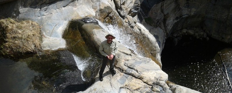
My pick is Duck Creek Falls. It really falls, a double, with the first a sheer plunge of sixty or so feet, the second maybe of eight. And the setting! It works its magic deep in a curving canyon of rose and golden granite.
Yet Duck Creek falls, my nomination for best of show, is largely a secret. Why? Location, location, location.
It is off the radar, hidden in the central Laramie Range, deep in the back country of the Laramie Peak Wildlife Habitat Management Area. The area is managed for wildlife–elk, bighorn sheep, deer and antelope–not for people. So there are no signs marking the rambling maze of roads. There is no constructed trail to the falls. There is no trailhead parking area.
And there is the name. If the early map makers had penned “Golden Canyon Falls” it might just have made a mark. But then there wouldn’t be the wonderful solitude of what might just be the wildest region in this corner of the state.
Playing hard to get
My friend Rob and I hiked in recently. We wanted to see the flow after such a wet spring. And to find out just how long it would take an average hiker to walk
it. Our verdict? An hour and a half from the dirt road. But a week later Rob took his family. It was three hours. Plan on two.
And the drive from Cheyenne? About two hours.
Was it all that I had remembered it to be from previous trips? Ah yes, and better.
And could I write down simple driving directions to the trailhead? I think so. They are at the end of the story
Your hike
The hike begins with a walk down Hay Canyon, following the beginnings of a little stream. The first hour of the hike is the downward drop through ever narrower and deeper canyon. Views of Reese Mountain, a twisted top of pink granite, greet you as you begin the gradual descent.
The user-made trail generally follows the right bank of the creek. Be careful not to get too high on the canyon walls. The route becomes very brushy, with branches pulling at your hat and clothing. Wear long pants and probably a lightweight long sleeve shirt to avoid scratches. And dose yourself well with insect repellant. This is tick country.
Keep an eye out for big horn sheep. A heard of about fifty have been successfully transplanted here by Wyoming Game and Fish. You’ll see plenty of bones, picked clean by coyotes.
After about an hour of walking, where the stream bed narrows into a notch, you will want to be on the left bank of the creek. A rope is secured to help give a helping handhold down the only steep passage.
After the notch continue a short way until you reach an opening and the junction with Duck Creek. You will turn left, going up-stream now along Duck Creek. Note this junction carefully for your return trip. It is amazing how the opening to Hay Canyon is concealed.
Here the rock walls are nearly perpendicular, towering over the lush canyon floor, grey and silver, streaked with bronze and black lichens. Duck Creek gently meanders back and forth, hosting a forest of spreading box elder trees.
Keep an eye out for the rare Laramie Columbine, a diminutive yellow bloom growing in rock cracks on the walls, found in this range and nowhere else on earth. Also keep an eye out for poison ivy which is abundant as the summer progresses.
Make your way as best as you possibly can, crossing the creek as needed. The creek makes a sharp bend to the left. You are getting close. Keep keeping on. The first sight of the falls is always a surprise.
The Falls
From high above the water flows clear and cold, fanning over a polished rock, filling a trough, then pushing out through a small runnel to plunge into thin air, breaking into fine spray as it crashes onto recalcitrant rock outcrops. If the sun is high and clear a small rainbow forms in the water just as it hits the upper pool. There the waters collect, black and dimpled before flowing out over a second fall into a lower pool with a sandy shoreline.
If you wish to make your way up to the top of the falls first back away and find a route up the left side to a long horizontal log. Traverse above the log, picking a way roughly level with the ledge where the fall begins. From the top look up to see a dark rampart of rock like an ancient ruined tower complete with openings to conceal archers.
Enjoy your lunch at the falls. Fish a little if you like. The trout here rarely see a hook.
The walk back can take a little longer. You are heading uphill. If time permits you may want to explore Duck Creek further beyond the Hay Canyon entrance. Here you’ll find fresh beaver construction and rising pools. The rock walls take on a rosy hue.
It is hard to believe that such a small creek, draining a little water shed could carve such a deep canyon. Some geologists believe that a large stream, such as the Medicine Bow River draining the Snowy Range, cut the canyon and then was diverted by a landscape changed by one of Yellowstone’s mighty explosions.
Getting there
I’ve posted a driving map you can copy at the end of this article.
Go north on I-25 toward Wheatland about 60 miles, taking exit 73, Hwy 34 toward Laramie. At 15.6 miles turn right on Tunnel Road. After 15.7 miles on Tunnel turn right into the Laramie Peak Wildlife Habitat Management Area. This is where the adventure begins.
The land is open, rolling and full of wonderful rocky outcrops with groves of pines. If Paul Bunyan played golf, this would be his course. You can imagine him striding over each hill, Babe the blue ox carrying his mighty clubs.
On the two track go straight for 1.7 miles, keeping left at each fork until you reach a “T”, Turn right there and then right again in .1of a mile. .3 beyond that keep left at the “Y”. Go another .4 and turn right at that “Y”. Then .7, keeping to the left at any intersections. You will pass two tractor tire water tanks and then see a wooden stockade to keep hay away from hungry elk. Park off to the side of the road even with the stockade. To your right is lovely Hay Canyon, the start of your hike.
End notes
Some precautions are in order. May and June are the best months to visit. Mid-summer is hot, humid and poison ivy rich. From February through April the area is closed. Fall is ok yet the water flow will be low and hunters may be present.
There is no drinking water and are no toilets. Do bring a trowel.
The only useful maps are the USGS quads “Davidson Flats” and “Bull Camp Peak.” Some further information on the Wildlife Habitat Unit may be found at https://gf.state.wy.us/accessto/whmas/laramie.asp
For now there are no gas stations at Chugwater. You will want to leave Cheyenne with a full tank and on the way home a detour through Wheatland could be in order.

Comments
Aaron
Jul 4, 2013
Can you tell me how to get to the waterfall at veedawou
?I have been there 2 times but cannot find it…people think i am crazy lol
Roger Ludwig
Jul 8, 2013
There is a waterfall there, more of a cascade, water running over and under rocks. It does make for a fun scramble, following the stream down. To get there go to the very end of the Vedauwoo area parking, to the north east. There is a new pit toilet there. Then continue on foot to the north east. It is not hard to find. The water actually comes through a large pipe all the way from Rob Roy reservoir in the Snowy Range, then up at a pond and down this little tributary of Middle Crow Creek. It eventually ends up in Granite Springs Reservoir and the water supply for the city of Cheyenne.
Kevin K.
Jul 31, 2013
Nice Trip Report. We ventured up to Laramie Peak this summer for the first time and have put this falls on the to-do list.
I am curious if you know anything about Sand Creek Falls? I found this picture in the UWyo archive and am somewhat familiar with the area, but never have heard or seen of the waterfall. Do you know anything about Sand Creek Falls? Thanks
Here is a link to the picture.
http://digitalcollections.uwyo.edu:8180/luna/servlet/s/49k379
Roger Ludwig
Aug 1, 2013
That is quite a picture! Sand Creek in Albany County is a wash that flows north from Colorado, meeting the Laramie River near Hutton Lake Wildlife Refuge. No big water or big granite boulders that I know of. I wonder if the photo is mislabeled. There are many Sand Creeks in Wyoming….
Lane
May 24, 2017
I think that might be the sand creek that flows into the north for of the Popo Agie right before it drops into the canyon. I’ve been there. It looks sort of like that…
Kevin K.
Aug 1, 2013
I agree that the environment in the picture does not resemble that of the Sand creek in Albany county. I do believe the fall is somewhere in Wyoming…
On the topic of sand creek, Albany county, are you familiar with any of the stone formations by the border and around 287? The Bonney white book talks about sitting camel (chimney rock) and in the surrounding areas, animal traps (lions den) We have been down by sitting camel, but our adventure was inhibited by private property.
Is there much exploring to do in this area without trespassing? We enjoy the unique wind sculpted formation around this area and maybe you know of a legal way to see them?
Thank you
Gail Thompson & Bob Tuck
Jun 12, 2014
The falls in question are the Popo Agie Falls and Sinks SW of Lander. Here is a link to photos taken about 1928. Even the stick is in the same place. It is truly amazing.
The photos are thumbnails, but you can double click to expand. http://digitalgeographer.com/duck-creek/
Brad Murdock
Jun 4, 2015
Hi Roger,
Went to Duck Creek Falls last week. The hike was very intense, and took us several hours mostly due to the intense overgrowth from all the rain and snow this spring. Duck Creek was also very high, which forced us to wade through waist-deep water over a dozen times to get to the falls. The area also looked like it had experienced a flash flood in the recent days, as many trees and branches were ripped up and strewn everywhere, with a lot of mud as well, which made the trip even more difficult. Even though it wore me out, the hike was very beautiful and the falls were even better. I was expecting something akin to the photos you posted, but was welcomed with a much bigger fall and a pool deep enough to swim in if you wanted. Unfortunately I couldn’t get my camera to the upper pool by the rock because it was too deep, but I got some great photos nonetheless.
https://farm1.staticflickr.com/531/18431039356_a517206590_h.jpg
Charlie
Jun 4, 2015
I tried to go to Duck Creek Falls today. I parked parallel to the hay stockade and started by following the stream down Hay Canyon. I kept on hiking for 2 hours and still could not find Duck creek, so I went back and still could not find Duck Creek to the left. Is there some landmark I can find to notice the proximity of Duck Creek besides that rope which I also could not find.
Bee
Jun 15, 2015
I hiked there this past weekend and the vegetation is really thick, once Hays Canyon really narrows it becomes a real bush bash. It took us over 2 hours, getting through the veg and not being sure at what point to cross over to the left bank, we did some crossing back and forth.
You need to get to the point where it does become a notch with both canyon walls coming in. The right bank becomes almost unpassable. If you are high enough on the right side (ie out of the bushes) you can see the right side of the canyon becoming much steeper and there is a grove of tall, straight trees right around Hays Creek. Just beyond that is the opening into Duck Creek canyon, but you will have to cross to the left bank and you can’t help but find the rope, there is almost no other route down the creek. The rope is tied near a six foot waterfall on Hays Cr. that was quite full and worth noting on its own.
Roger Ludwig
Jul 6, 2015
Sorry to hear you had such a hard time. The creek valley gets narrower and narrower as you approach Duck Creek reaching a fairly narrow “gate” (I wouldn’t call it a “slot.”) just before Duck Creek. There are ragged rocks on the left if I’m remembering it correctly. It is possible you reached it, went right and continued downstream without noticing it. Do you have a GPS? We placed a geocache near the falls a few years ago. It is at N 42° 00.132 W 105° 24.453
UTM: 13T E 466248 N 4650100
The cache is listed as “Sanctuary” on the web site http://www.geocaching.com
Mike Morris
Jul 11, 2015
Roger,
Hope all is well – thank you for compiling this site, it really is a tremendous resource for folks in this region who are looking for new adventures. It was certainly the catalyst that spurred us for quite the adventure, ourselves, when we went hunting for the ever-elusive Duck Creek Falls this afternoon.
A quick disclaimer for everyone trying to get there: there are some new obstacles that are apparently imposed by the conditions this summer, and you’re in for a much bigger trek than described here due to some road closures.
We took Tunnel Road all the way to the first right into the Laramie Peak Wildlife Habitat Management Area (the 2-track that I believe is described here). My friend’s phone (he somehow was able to pull up Google Maps) called it Elmer’s Road. Whatever it’s called, it appears to closely match the 2-track description on the map provided.
In any case, there are signs posted that proclaim “Road Temporarily Closed to Vehicles Due to Conditions.” We didn’t want the trip to be all-for-naught, so we parked our vehicles at the base/entrance (down at the bottom of the 2-track that is mapped out) and hiked all the way up to the “trailhead.” It was easy to see why the road was closed. There are deep, jagged ruts in the road and it’s really impassible in a lot of areas. In fact, there were some huge granite stones in various parts that made me question how accessible it ever has been on anything short of an ATV (I don’t even think most four-wheel drive trucks would get up it). Anyhow, the road is in tatters due to the soft soil conditions from all the moisture this spring/summer, so in order to get there, you’ve got to hike in on foot.
This means that, before even getting to the “trailhead” for this hike, you’re adding an extra 6.5-7 miles onto your trip if you want to do it. We also got lost looking for the trailhead, so we probably hiked roughly 10 miles roundtrip that weren’t even a part of the hike described here.
…and the crazy part of all of this? We’re not even to our experience looking for the falls this afternoon. We backtracked and found the wooden stockade/the tractor tire water tanks (which are slightly spaced apart, by the way)…and then found the beginnings of a mountain stream running eastward (maybe slightly southeast?) into the canyon. The vegetation around the stream is massive and the ground is often mush, so to those of you reading this blog, HEED ROGER’S ADVICE AND WEAR SLEEVES! You’re not only in the middle of tick country, but tons of thorns and thistles and other nasties.
Anyhow, we ventured all the way down the canyon looking for where the Duck Creek tributary runs into the creek you’re following. Long story short, we never found it. No sight of the rope (although I think we did find the extremely narrow “notch”), no certainty of when to cross over to the left.
We did, however, cross over back-and-forth several times, and I believe we overshot our destination and went too far east. It’s entirely possible that we passed by accident onto private land in crossing the stream several times, because we ended up down near a cabin (which was a jarring surprise given that we were so deep into the wilderness). Even more shocking, we discovered what appeared to be the frame of an Oregon Trail Conestoga wagon and two marked gravesites that seem to be extremely old. Has anyone stumbled on these? I don’t recommend that anyone goes searching for them (especially if it entails trespassing – please have respect and don’t intentionally trespass, we certainly weren’t), but could someone give frame of reference for where we may have gone awry looking for the falls? If anyone has, of course, also encountered these. Did we overshoot it completely? Were we probably on private land, or is this still somewhere in the vicinity? Just trying to have an idea for where we may have erred…I’d love to find this thing without GPS assistance, but it seems awfully difficult this summer given the blessing of rain we’ve received.
Anyhow, long story short – if you’re skimming to the bottom – be very, very prepared coming out here. The vegetation is super dense. There’s also a ton of tall-grass, and even though it’s been a cooler summer, do be wary of rattlesnakes, as there are a lot of deadfalls for them to hide under. We didn’t see any, but we saw a few small lizards, meaning that the climate is still conducive to reptiles. And, finally, bring a TON of water and give yourself plenty of cushion as far as daylight, because the hours can really add up out there.
Be safe and enjoy! It’s beautiful and I’m determined to find the falls sometime soon.
Roger Ludwig
Jul 14, 2015
Mike what an adventure! I have no idea where you eventually ended up but I’m intrigued to explore the area. Since your post I’ve been pouring over every map I have to figure out what happened. You probably took the wrong turn off of Tunnel Road. From what your friend said and your description I think you made your right turn on to Elmers Rock Road. It heads to an area that the rock climbers call the “Toaster Wall.” Check out the map and photos on this site to see if it looks familiar: http://www.mountainproject.com/v/the-toaster-wall/107472219. Some hike past it toward Moonshine Peak.
If this is the spot you must have gone beyond the Toaster Wall on your hike down some unnamed canyon. There is private property beyond Elmers Road that is still in the Habitat Area and then more beyond that that is not.
The correct turn into Duck Creek is the next road past Elmers Rock Road. Tunnel Road generally is running west but makes a sharp turn to go due north for about a mile and a half then turns left to go west again. After that left 90 degree turn it is about a mile and 3/4.
For a map that shows most of these roads and two-tracks the BLM “Rock River” is probably the best. They are for sale at the BLM building on Yellowstone Rd for just two or three dollars.
I have often thought that driving around up there and finding your way is the hardest part of the trip. I’m coming to love using smart phones or iPads with a trail navigation feature to know just where I’m at while driving. “Trimble Outdoors” can be a good one to try. They are usually not much more than curiosities on the trail but on the road they have saved my bacon.
Thanks for your post and for sharing your arduous experience! Roger
Mike Morris
Jul 15, 2015
Roger,
Wow. It’s unfathomable in retrospect, but you’re completely right – I believe we walked up the wrong “closed” road, especially given the analogous comment at the bottom of the Toaster Wall page.
What is incredibly strange, however, is that the road we walked on bent to the north and seemed to have similar features to the one depicted on the map. We picked up the small beginnings of a mountain stream immediately across from a wooden stockade. There were two tractor-tire water tanks in the vicinity. And the creek went eastward into a canyon, which revealed itself as progressively more and more narrow and overgrown with thorny bushes. The way it matched your description of the Duck Creek Hike was absolutely uncanny and bizarre.
In any case, our crew will take another swipe at the Falls here in a couple of weekends. However, if you’re interested in exploring the route we took, I’ll provide you with this: follow Elmer’s Rock Road all the way up until you run into a black, wooden stockade. The creek will begin to flow eastward from there. There should be a couple of tire tanks in the near vicinity, as well. We stumbled on a recently eaten elk carcass in the tall grass near the creek, so there are clearly some larger predators in the area. Continue east/southeast through the canyon and eventually you’ll be forced to cross over to the left side of the bank (because of how narrow the right grows). At some point, you’ll run into the wagon and the graves. It was one of the most eerily jarring sights I’ve encountered in a while (simply because it felt like it had been a LONG time since anyone had even been in the area), but it’s definitely neat. I’m sure there are a number of other interesting things around, too – there were a few other roads in the area that were “closed” to vehicles that appeared to lead to interesting paths. Almost zero sign of human presence anywhere (other than the cabin) – we found a heavily rusted steel can, but other than that, no footprints or any sort of markings in the area.
I’ll try to post a couple of pictures of what we saw sometime in the near future. Until then, thanks again for the directions and guidance – I’m a lot more confident that we’ll be able to find the falls now.
Best,
Mike
Matt
Apr 10, 2020
Mike,
Do you happen to have any images of the wagon site? I’d be interested in checking this site out as I’ll also be visiting Duck Creek this summer.
I’d be happy to give you my email.
Thanks,
Matt
Brett
Aug 16, 2015
I’m pretty excited to go take a look at this site. Does anyone have any further updates that are worth noting? Also has anyone fished in this area before, or have you seen any fish jumping out of the water? It looks beautiful and its definitely a great find. Thank you for posting this, what a great site.
Tom
Jun 5, 2016
Brett,
We just visited and you can watch fish jumping (or trying to …) from the tiny falls into the upper pool at regular intervals. Definitely some energetic fish!
Gabe
Sep 6, 2015
Just wanted to say thanks. Details were perfect, falls and fishing were great.
Damocles
Jun 18, 2016
Hi Roger, just curious, are there any public lands near Duck Creek Falls? We are thinking about heading here along with Laramie Peak in the same trip and would like to go camping someplace close by.
Roger Ludwig
Jun 19, 2016
So much of it is public. The entire Laramie Peak Wildlife Habitat Unit, where Duck Creek Falls is open for camping. Just camp where you feel like it. There are no developed sites. I’ve camped right off the Duck Creek trail head before in the open meadow.
Then there is all of the Forest Service, BLM and state land. The only developed campground in the area is Friend Park at the base of Laramie Peak. It’s very nice.
You can camp anywhere on Forest, BLM or state land but you may be sharing your site with cattle. Because the Laramie Peak area is such a patchwork of land ownership maps are really helpful. One would be the Medicine Bow National Forest Laramie Peak Unit, which is best for roads. The others are two BLM maps, Laramie Peak and Rock River. The Habitat area straddles the two maps. They are available for $4 each at the BLM office on Yellowstone in Cheyenne. Unfortunately the Habitat is not marked on the maps so you have to print off a Habitat map from the web and try your best to correlate them.
Damocles
Jun 21, 2016
Hi again Roger, thanks for the quick reply and the great information. We love your site, thanks. I’m really looking forward to our summer adventure.
Lane
May 24, 2017
I thought you were not allowed to overnight camp on state land. 🙂
Roger Ludwig
May 25, 2017
Camping is not allowed on State Trust Lands. Here is their site with the prohibitions: http://lands.wyo.gov/resources/recreation Here’s an interesting, although rather old, answer to that from the Casper Star Tribune: http://trib.com/news/local/answer-girl-camping-on-state-land/article_6c38a9bc-3ae2-518b-ad16-128030cc5318.html These are the “school sections,” usually shown as blue or purple on maps.
Camping is OK on WMHA lands unless prohibited. Here’s a link to all of the WMHA area’s. Clicking on one will show a map and any special regulations. https://wgfd.wyo.gov/accessto/whmas.asp
Wyoming also owns State Park lands, like Curt Gowdy or Guernsey Reservoir. They will have their own regulations that show where camping is allowed. All of the different types of public land in our state can make things confusing.
Roger
Andrew Bryson
Jun 20, 2016
Made my maiden voyage to Duck Creek Falls on 6/19/16.
Brush in lower Hay Canyon is near impenetrable in places,
but broken branches show that the trail is used.
Much Poison Oak & Stinging Nettles in addition to ticks & snakes.
The Gorgeous Falls & solitude make up for the extra effort needed to get there.
One note: we used a GPS to measure driving distances and found the description here to be a little short in most instances, but excellent otherwise.
Chad H
Apr 28, 2024
You didn’t happen to create a GPS map of the hike you could share, did you?
Roger Ludwig
Nov 2, 2025
No, that was before the days of easy route marking on our phones. Sorry.
Hillary Carlson
Jun 21, 2016
Roger and Friends,
We had a great adventure. My cousin and boyfriend and I went to the falls on June 10th of 2016. The details were great. Although the we did have a discussion as to what a notch in a creek exactly is… Haha we concluded it is a “mini waterfall” where the creek changes height a bit. That is where the rope is. We were in the canyon on the right of the creek where it was getting more and more narrow and eventually came to a big opening or crater-like cliff on the right. If you pause here and survey the land below and look straight down and to the left of the creek you should be able to see the end of the rope!
Some things to be prepared for:
Bring lots of water and snacks. The hike back is much more difficult than the hike there. We experienced a down pour of rain on our way back!
Ticks and thick grass and bushes and trees! Wear long sleeves, hiking boots and pants as suggested. And bring bug spray! We doused ourselves in tick bug spray and still had to stop every now and then to swat ticks off each other.
The drive there is pretty easy in our Kia but the roads were sometimes are rough and it would have been better to have a truck or SUV type of vehicle.
When you get to the falls you can swim but the bottom of the pond is rocky and tore up our feet. If you plan on getting in the water bring water shoes. We also saw a snake slither across the water! This was after we swam. That might have changed our plans to swim if we saw the snake beforehand.
Overall, this was the best hike I’d ever been on. Beautiful views and the destination was so worth it!
Thanks for the information!
Hillary
charles
Aug 23, 2016
Dear Roger,
This question I have for you is not about Duck Creek Falls but about Cottonwood Falls nearby. When you approach Cottonwood Falls by car or when you get out of the car at the parking lot and hike to the fall, do you have to travel down a canyon no matter how imperceptible or large it may be?
Roger Ludwig
Aug 23, 2016
Hi Charles,
Are you asking about Cottonwood Draw Falls, near Grayrocks Reservoir? There are other Cottonwood Falls around the region. For Cottonwood Draw Falls, from the parking area at the end of the dirt access road you just go through the hikers gate and walk up the draw. It is a broad area at first and gradually narrows to canyon. The trail at first parallels the creek and then drops down into the creek bed itself.
Derek
Aug 23, 2016
Hi Roger,
Thanks for the Duck Creek article. I also enjoyed your article on Cottonwood Draw Falls.
I have some of the BLM maps, which are a good start, but I like the USGS 7.5 minute series maps (you mentioned Davidson Flats and Bull Camp Peak). I’m new to Wyoming and haven’t found any of those yet. Can you tell me where to find those in Cheyenne? and can you tell me how tall Cottonwood Falls is? (as opposed to Cottonwood Draw Falls)
Thank You 🙂
Roger Ludwig
Aug 25, 2016
To my knowledge there are no locations in Cheyenne to buy USGS maps. I know that the local USGS office does not sell them. They are available for sale online at: https://store.usgs.gov You can buy printed copies from them or download maps for free. There are aps that will allow you to put the USGS maps on your phone or tablet and then use the locator features to navigate by them. My friend Al Walsh explains how to do this on his site, http://www.justtrails.com.
I’ve never been to the Cottonwood Falls in the Laramie Range. I know it is either on or borders private land so I’ve never checked it out. If you do, please let me know what you find.
Roger
Derek
Sep 7, 2016
Thanks for the info Roger 🙂
I just started school, so I may not be able to get out again until next spring, but hopefully I’ll have some time on a weekend. If I do, I’ll let you know!
Lane
May 24, 2017
Hi Roger,
Great post! Can you explain to me the legality of access to Duck Creek falls? So anything within the WHMA is public even if it’s not marked as BLM, State, or Forest Service? There are pockets of private land withing the WHMA, correct?
Roger Ludwig
May 24, 2017
Any private land within the WHMA is open for hiking, hunting, fishing and climbing but it is still private land. Landowners have sold an easement to Wyoming Game and Fish that allows public access. If you happen to see ranchers working the cattle up there they are typically friendly and helpful. There are also some private land pockets that are in the area but not officially in the WHMA boundaries. That land is not open for public access. They should be posted with no trespassing signs. There is one of these in the duck creek canyon but it is not posted and the owner has allowed people to walk through.
Roger
Don Odom
Jun 9, 2018
Recent transplant to Wyoming and rookie hiker at age 55. I’ve hiked Vedauwoo, Red Mountain and Soapstone Prairie in CO.
I’m looking for bigger challenges and this intrigues me as a possibility.
Anyone been there in 2018?
Brian Gabel
Aug 27, 2018
I am 51 and took the challenge last weekend. I did fine except my knees and feet were quite sore afterwards. I work out 3x a week with machines and cross trainers but I would suggest, from my own experience, work out legs much more on machines as well.
That being said, this not, repeat NOT an easy hike for an average out of shape American. Being a retired veteran, I tend to pack more shit than what I might need. I also took my 6 month old German Shepherd Dog and he was a real trooper.
If you are not familiar with the area, research before you go. I know the area fairly well as I have friends who have ranches there and know the way in. Roger’s direction to the entrance are easy to follow. Once in the Hay Canyon though, you are on your own. I was getting a bit anxious like a kid, are we there yet? are we there yet? but when I looked at the cliffs to where the two creeks meet, I soon found the ropes and knew I was close.
Take plenty of water. More than what you think you will need! In addition perhaps a small filter emergency straw type as well. On the return trip, we drank our last water about a mile left to where we parked the Jeep. It is easy to get dehydrated.
I also packed a good first aid kit, knife, collapsable shovel, rope, extra socks, another set of boots (you might need dry ones later, especially if you swim in the pool) bug spray, MREs, a good boonie style hat, mechanix type gloves,GI issue compass (or GPS) a good topo map,and something for defense of black bear. There are lots of sign of bears e.g. scat along the trail. Bring EPA bear spray and or firearm if so inclined. A 44 mag or 45 ACP minimum IMHO. Make sure you can grab them in an instant while hiking.
Next time I am bringing a machete, small branch saw or the like. And even though I enjoyed taking my dog, I may leave him home next time. It’s doable, but he needs water, food and help in some spots. He is 67 pounds now and 6 months old, but carrying a fully grown GSD is not easy if a guy has to.
If going alone, definitely tell someone where you are going and when you expect to return. Finally, do not, absolutely DO NOT make any campfires in the area! I grew up in Platte County and the fire danger is very real! Pack some fire making tools just in case and ONLY as a last resort! e.g. life and death scenario.
This hike is not a nice groomed trail or something a national park has set up. If you can’t stand being scratched, poked, bitten and or bruised, stay home. ☺
Stephanie
Jun 29, 2018
Have you heard of Horse Creek Falls? I have seen pictures
But can’t find out how to get to it.
Roger Ludwig
Jul 10, 2018
No I haven’t. I’ll keep it in mind and ask around.
Joe
Jan 10, 2021
Horse Creek Falls are located just a couple miles West of the community of Horse Creek (which is like 5 houses.) You get there taking the horse creek exit just north of cheyenne and driving west to horse creek (something like 20 miles) the problem is that the falls and all access to them are on private land. You’ve got to know the landowners.
Michael Littleton
May 22, 2020
I found the waterfall and it was everything I expected and more. On a side note, getting lost is very easy. What was supposed to be a 6 hour trip, took 12 due to getting lost. In the end, it was still worth it.
Hillary
Jun 7, 2020
Hi Michael! What was the tick situation when you did this? I did this hike a few years ago in the spring and it was crazy with ticks. We were constantly swatting them off each other.
Also glad you made it out of there despite getting lost 🙂
Thanks for the info,
Hillary
Bill McCleary
May 27, 2020
Do you know where you got off the trail? Do you have any pictures? Did you find the wagon? Do you have GPS Coordinates? I would love to do this walk but 12 hours is a little more than I can do. Did you take your dog?
best Bill M
James Amato
Jul 6, 2021
Roger, thank you for sharing! We found the Falls pretty easily with the directions provided. Water was flowing pretty good; upper pool was just deep enough to take a swim. We didn’t run into any ticks, we did see a couple non venomous snakes, we did run into LOTS of poison ivy so make sure to wear pants! The rope is still there where the canyon narrows. It took us 2 hours to get there, and just under 2 hours to get back. I definitely would avoid bringing a dog. It was a fun adventure, and the Falls are definitely a true beauty. Cheers
Tj
Jul 9, 2022
I’m a little concerned about your directions. From what I can tell, the two track rd your referring to is all on private land. Are there markers indicating the public has permission?
Roger Ludwig
Oct 6, 2022
Sorry it has taken so long to get back to you. Yes, it’s on private land but the landowner has approved access when becoming part of the Laramie Peak Wildlife Habitat Management Area. When you turn into the Area there is a signboard with a map.
Wyoming Jon
Jun 11, 2023
I went today,the 10 of june 2023. I made the mistake noted above. On tunnel road, the first road on the right labeled as laramie peak management area goes to the trailhead for toaster wall, as well as a couple other trail heads on the way. A few more miles down tunnel road is the second road on thw right, that has the same signs, and is the one rodger is talking about. When you get to the T in the road he describes, if you can see ranch houses 1/2 mile to the left, your on the right road. We didnt see any ticks. Did see the remains of an old cabin. The first 3 miles are easy grassy meadow, the last two miles of hay canyon were nearly impenetrable brush. The creek has cut a narrow channel through the steep clifs, and it is packed full of buckthorn and briars. The short stuff was nearly waist high, the tall stuff was taller than me. We tried a short cut over the ridge to get more directly to the fall, do not attempt this. The back side is a straight drop, and at the end where the creek bends, it is dangerously steep. Getting caught up there during a lightning storm was quite harrowing. Do be careful for lightning. Many toasted trees are on these slopes. Enjoy the wonders of the gentle meadow of hay canyon,but understand the laramie range has a tendency to go from gentle meadows to the most rugged impenetrable terrain in an instant, without any transition. The weather tends to be the same way as well. We did see a herd of mountain goats. The woodland roses were beginning to bloom. And we found giant puff ball mushrooms. Reminded me a lot of the blair and wallis picnic areas over by bufford. The 20 miles of dirt tunnel road was rather treacherous in the downpours today. There is a unique hostorical sight called the wheatland tunnel just down the road. The johnson creek reservoir is just past tunnel road on 34. The laramie range is an overlooked wonder.