Signal Mountain: An athletic hike to a stellar view
The information in this piece may be out of date. I have moved away from Cheyenne and am no longer maintaining this site. You may leave a comment if you wish. Useful comments will continue to be posted.
If you are interested in an athletic hike to a great view I’ve got two words for you: Signal Mountain. It is athletic in that there is a 3,272 foot climb over 5.9 miles, yet not technical. A trail guides you all the way to the summit.
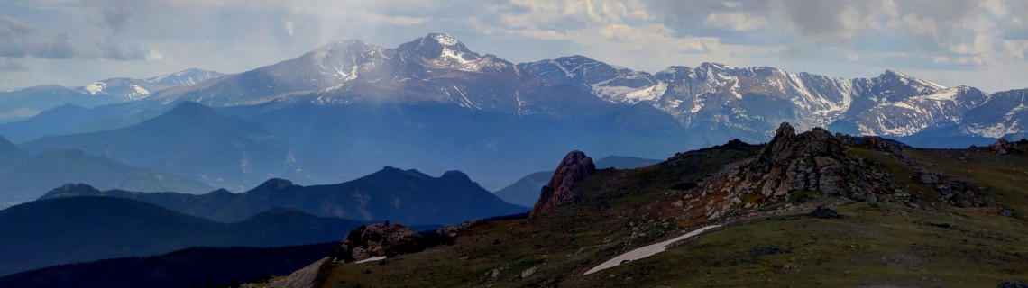
The view? A close-up of the Mummies, that great range on Cheyenne’s distant south-western horizon. In fact Signal Mountain is the first peak that rises above tree line in the Mummy Range.
The hike takes you to the edge of Rocky Mountain National Park, letting you peer into it with no fees, no traffic and probably no people.
I like this peak, too, because the top is a lovely mound of tundra, strewn with mini-blossoms, unlike so many mountain tops of broken, wobbly granite.
The hike
Most of this long hike, 12 miles round trip, is in the shade of the pines. The trail drops down to a small creek, crosses it and climbs up over a little ridge before dropping down to larger Pennock Creek. The trail follows this lovely run of water for several miles..
As you begin the walk up Pennock notice the crumbling remains of a large old cabin on the right, complete with hub caps. Every cabin needs hub caps.
Past the cabin, near a shed, are the remains of a ruined fish barrier. The plan was to keep non-native trout from coming upstream, using Pennock’s fine waters to nurture rare greenback cutthroats, the Colorado state fish. The creek had other plans and breached the dam a few years ago. Brookies and browns made a run for it and have repopulated the creek. I guess they resented those “Native” license plates. Fishing is still prohibited upstream from the barrier.
Deep in the shade there is just not much to see. A lovely stream, healthy pine and spruce forest, stands of stately aspen, a few meadows across the creek ablaze with golden banners. Beavers building new dams. Rare pink fairy slipper orchids along the trail. And at the stream edge marsh marigolds and globeflowers, both wearing creamy white petals, yellow centers. There are occasional rock outcrops, including a rough and ragged spire with a slit of a window hovering overhead. Really not much to see.
The trail is well cared for until it pulls away from the creek to ease the grade. Here a microburst has left a cataclysm of downed trees that continues to the tree line.
The kids and staff of Sky Ranch Lutheran Camp are putting their faith to work, clearing the way. They’ve cropped a lot of branches to make climbing over the logs easier and there are new routes around the worst of the log piles.
Eventually the trail reaches a saddle. There are some campsites up here as it is flat enough and campfires are allowed, yet no water nearby. Signs point the way to Signal Mountain, the trail now zigzagging up a ridge. Keep an eye out for orange survey tape and cairns bringing you back to the way.
Finally, the moment you have been working for. In true “Sound of Music” style the trees give way and you are loose on the high meadows, following cairns and a faint trail to the summit, 11,262’. At the top a windbreak of rock has been built to provide a little shelter as you survey the view.
To the left is Mt. Meeker, then mighty Longs Peak, and the expanse of the Mummy Range: Dickinson, Dunraven, Mummy, Hagues and Rowe. To your right, in the distance, sparkle the snow-clad Rawahs. Be sure to get credit. Sign the register rolled in the white tube.
Slightly below is South Signal Mountain. Many will want to make the down and up to top this peak in order to “bag” two summits in a day, getting the view down into the North Fork valley, and putting their foot across the Park boundary. Many others will be ready to call it day.
Getting there
The trailhead is on Pingree Park Road south from the Cache la Poudre river canyon. From Cheyenne, WY, take I-25 south to Wellington, then follow Colorado 1 toward Ft. Collins. When you reach the junction with Colorado 14 turn right. Staying on 14 you’ll turn left at Ted’s Place into the Poudre Canyon. After 75 miles or so from Cheyenne, just past Kelly Flats Campground, turn left on the Pingree Park Road, CR63E. Take 63E 12.6 miles to the signed trailhead which is just beyond some private cabins.
There is no trailhead parking area, just wide shoulders on both sides of the road. It takes about two hours to drive there from Cheyenne.
Tips and cautions
As with any Rocky Mountain peak storm clouds bringing lightening often come in the afternoon so an early start is safer.
Plan on at least six hours hiking, perhaps seven, for the round-trip to Signal. There is no drinking water and are no “facilities,” only a sign posting a map and regulations.
Dogs are allowed, on leash, or “under voice control.”
For maps “Trails Illustrated Rocky Mountain National Park” by National Geographic” is excellent for this hike and so many more.
If you have never seen Pingree Park, the CSU natural resources campus, it is well worth the extra few miles’ drive beyond the Signal Mountain trailhead. The setting is spectacular.
Several other fine hikes begin near Pingree as well: Stormy Peaks, Mummy Pass and the gorgeous Emmaline Lake.

Comments
jacob
Mar 31, 2014
Well maintained unofficially by Pingree as well. Love your article.
greg
Jun 9, 2014
nice piece! one can also access signal mountain from the dunraven trailhead via bulwark ridge, it’ located on the north side of devils gulch road between the towns of drake and glen haven in the north fork of the big thompson canyon. it’s also a great hike about 6 miles and 3200 vert to the summit and plan on 6 to 8 hours r/t if your in decent shape. in spring and early summer to avoid postholing aim for the south summit first to gain access to the vast sno-free saddle and lots of scrambling opportunities. this hike is strenuous and requires some rout finding dicipline at times but always an excellent adventure!
Dillon Sarnelli
Dec 26, 2014
Nice write up! I’m thinking of heading out to give Signal a winter go from the south this weekend. Thanks for the info!
Roger Ludwig
Dec 27, 2014
Let me know how it goes. I gather the road is open to the CSU campus….
By the way, readers should check out Dillon’s remarkable web site: http://www.ExploreTheRockies.org
Great trip reports and some fabulous photography.
Dillon Sarnelli
Jan 5, 2015
Roger,
I just saw your response! Thanks for the kind words. Much appreciated. It’s a joint effort over there on Explore the Rockies, about 10 of us! The different aspects keep it interesting :). I ended up doing Signal from the south – Dunraven TH – since I wasn’t sure if the road was plowed up north. It was a slog and a half in some deep powder, but a great bluebird winter day out. Quite a different perspective up there. I’m working on a write up. Keep up the good work on your site as well! I took a gander at few your reports after getting the low down on Signal from this one. Some excellent stuff on here! Happy New Year!
Mike Wingate
Oct 19, 2016
Can also access the trial via 4WD, the Ballard Road goes right up to the saddle before the last climb, which made this accessible to my Dad who is older (but still in good shape, just not up to the length of the Pingree route). You do need a decent 4WD with low range and decent ground clearance (read: no subaru’s or rav4’s/CRV’s).
Beautiful hike via any of it’s trailhead, be sure to sign the logbook on the north summit!
Patrick Terry
Jun 16, 2017
A little history from the past about this area. The route from Highway 14/pingree was my favorite trail to take beginning backpacker friends up to the saddle.
An interesting story how I found the area……….
In winter of 1967, I had been with a Mountain Rescue Team here in Colorado called Alpine Rescue Team for about two years and was a senior in High School. We were called into a private plane crash on one of the mountains to the North of the Saddle area.
We spent three days up there on snowshoes covering as much of the area as possible given the deep snow and un-believeable amount of deadfall. We didn’t find the plane.(it was white and it snowed about 18″ the first night we were camped there in our mountaineering tents) We were joined by two RMNP rangers because it was so close to the Park border. The end of the last day we had searched the entire slope East of the trail, got to the saddle, and snowshoed down and out the trail to the road. Another team found the airplane when the snow melted in the spring and brought out the two occupants of the aircraft who perished in the crash. I loved that area and have been up that trail with friends backpacking countless times. Back then, we never saw anyone on the trail and it was beautiful. I’m sure there are many other people up there now. Back then, there was a trail that left twin lakes and went around to South Signal peak so you could make it a circle trip coming back down pennock route and out on the pingree trail.