The Medicine Bow One Hundred
The information in this piece may be out of date. I have moved away from Cheyenne and am no longer maintaining this site. You may leave a comment if you wish. Useful comments will continue to be posted.
The One Hundred Mile Backpack Route
through the Medicine Bow National Forest of Wyoming
Cheyenne backpacker Shan Holyoak likes a long trail. One hundred miles at least. Six times he has hiked the Centennial Trail, 111 miles through the Black Hills, as a spring get-in-shape warm-up for bigger things.
Those things include the Superior Hiking Trail in Minnesota (232 miles), the Tahoe Rim around Lake Tahoe (165 miles), the Ouachita Trail in Arkansas and Oklahoma (223 miles). He’s currently working on the Appalachian Trail, having completed 1684 miles of its classic 2180. Has finished the Colorado Trail in two sections (486 miles). This spring will find him back on the 2663 mile Pacific Crest Trail, now famous from the book and movie Wild. He’s done the southernmost 454 miles and will go for the next 450 to 700.
Holyoak explained that, for him, long distance hiking is about achieving difficult goals both logistically and athletically. Big country deserves big accomplishments. “Sometimes when hiking, the enormity of where I’m at and what I’m doing hits me. It is as if a shot of adrenaline is injected directly into my heart. There are aches and pains, heat and cold, blisters, rain then there will be the perfect day.”
Retired from the Wyoming Army Guard where he served in the quartermaster corps, these trips are a continuation of his love for careful preparation. “I enjoy planning the trips and the logistical challenges, making due with what is available.” For Holyoak this means having just the right amount of lightweight equipment and food. Not an ounce more or an ounce less. He can enter a typical convenience store and outfit himself for another four to five days on the trail.
For Holyoak the Snowy Range and Medicine Bow National Forest west of Laramie are the home mountains, the area he probably knows the best. So when he read in the Medicine Bow National Forest “Visitor Guide” that “the Forest is ideal for short hiking trips” but that “extensive areas of remote backcountry do not exist for more lengthy trips” he was shocked in disbelief, and challenged, plunging into his maps.
Now, many trips and hundreds of miles on the ground since, he has plotted and through-hiked a one hundred mile route two times. By connecting trails, a few two-tracks, a couple of sections of dirt road and three short off trail bushwhacks he has created the Medicine Bow One Hundred, an approximately one hundred mile backpack route that makes a large backwards “J” starting at Sheep Mountain, nearing the Colorado line and then heading north to end at Arlington.
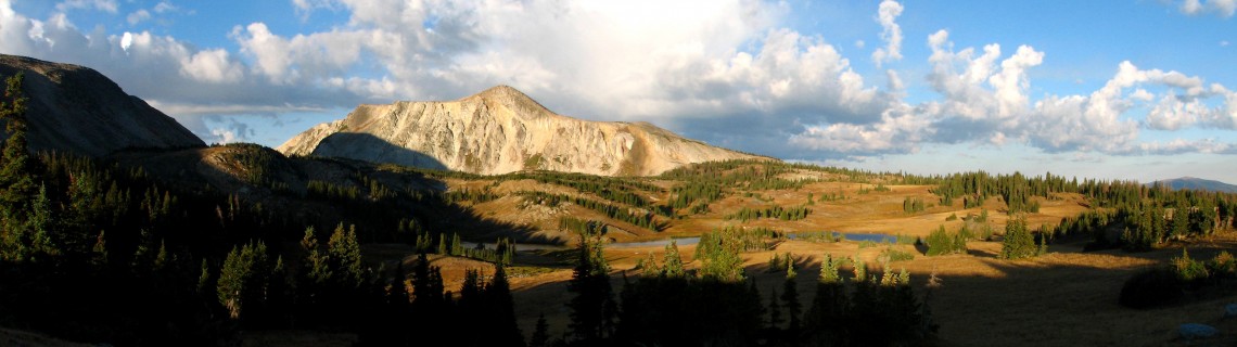
This is a terrific route, covering the best of the range with all its wonderful variety. It takes a hiker through the great high lakes and Snowy Range, transverses both wilderness areas–Savage Run and Platte River, drops down through the vast Rock Creek canyon, and bisects the little seen Sheep Mountain elk reserve. There are sparkling lakes, wildflower strewn tundra, open hillsides and deep old-growth timber. Hikers will find plentiful solitude through most of the trip as well.
It will be a challenge, too. One hundred miles is a long way. And the route is not signed so map reading and route checking will be vital. Yet this is easier than many long trails as there are places to cache food to re-supply along the way. A food package can even be sent to a lodge for pickup on route. Water is plentiful. No permits are required. You can put your tent anywhere gravity allows. Dogs are welcome.
With many road crossings the route lends itself to section hikes, too, allowing people with less extended time to knock off the complete one-hundred in several trips. In fact if a person can backpack 12 to 15 miles per day this trip could be done in four summer weekends.
The One-hundred mile epic
Here is the route. Two maps are needed, the basic $10 “Medicine Bow National Forest” (1998) and a clipped-out piece of the free “Motor Vehicle Use Map Medicine Bow National Forest.” Both are available from the USDA Forest Service office at 2468 Jackson Street, Laramie, WY 82070 (307-745-2300) or at area sporting goods stores. In the following guide Forest Service roads are noted as “FS,” state highways as “WY,” and trails as “#.”
Section One: Sheep Mountain to Medicine Bow Rail-Trail (18.0 miles)
Starting trail head: Forest Access at WY 11, 1.9 miles south of junction with WY 230.
Begin off trail, climbing south and southeast about 3.4 miles, until reaching Sheep Mountain Trail (#386).
South on Sheep Mountain Trail (#386) 10.8 miles to Fox Creek Rd. (FS 311)
North on FS 311 0.2 miles to FS 311A.
West on FS 311A 3.6 miles, crossing Lake Owen Creek. Follow the most defined two track, which becomes FS 311AA and then merges with FS 552B, until reaching the Medicine Bow Rail-Trail.
Notes. The start of the route with its steep off-trail ascent up Sheep Mountain may be the most difficult part of the entire trip. Some hikers may choose to hide their packs at the end of the Sheep Mountain Trail at FS 311, making a long 14 mile day hike from the access area, then grabbing packs and going up FS 311A to camp at Squaw Creek. Yet doing so makes for a long first day with no option to camp on the mountain. On Sheep Mountain Trail be careful to turn left at the Forbes Trail (#386.W) junction in order to stay on #386. Sheep Mountain is surprisingly wet with bogs, beaver ponds and plentiful wildlife. The wildlife often include mosquitoes so be prepared with repellant.
Section Two: Medicine Bow Rail-Trail to Pelton Creek Campground (26.7 miles)
South on the Rail-Trail 19.0 miles to FS 898.
West on FS 898 7.7 miles to Pelton Creek Campground.
Notes. The trail follows the rail bed of the abandoned Laramie, Hahns Peak and Pacific Railroad bed, making for a comfortable, gradual ascent. It leaves the rail route to detour Fox Park but is well signed.
The Rail-Trail nears the Wycolo Lodge at Mountain Home. They will be happy to provide you with a warm meal, a cold beer and even a room. If you wish to send a food parcel for your upcoming miles they will keep it for you. Ship by UPS to
(Your name), C/O Wycolo Lodge, Laramie, WY 82070. Include your estimated date of arrival on the package. Café hours are 11:00 am – 9:00 pm weekdays, 11:00 am – 11:00 pm weekends.
To get to the Lodge leave the Rail-Trail at Boswell Road (FS 526), going west 0.3 miles to WY 230 then north on WY 230 0.3 miles.
Gravel Pelton Creek Road (FS 898) is the only long road walk on the entire route.
Section Three: Platte River and Savage Run Wildernesses (27.5 miles)
From the Pelton Creek campground take Douglas Creek Trail (#506) northwest 9.1 miles to Sheep Creek.
North off-trail along the west side of Sheep Creek (begins at the Wilderness Boundary Sign) 2.9 miles FS 512.
East on FS 512 0.1 miles to FS 512V.
North on FS 512V 0.3 miles to Cottonwood Trail (#502)
North on Cottonwood Trail (#502) 1.8 miles to Savage Run Trail (#501)
Northeast on Savage Run Trail (#501) 4.1 miles to FS 500.1B.
Right on FS 500.1B 1.3 miles to FS 500.
Right on FS 500 1.3 miles to FS 568.
Left on FS 568 0.4 miles to FS 510.1E (note sign is missing the “5”)
Left on FS 510.1E 0.5 miles to junction.
Right on FS 510.1E (signed) 0.5 miles to FS 510.1G (note at the 510.1E junction 1E goes straight and right. Go right.)
Right on FS 510.4G 3.1 miles to 510.1H. (510.4G becomes 510.1G)
Right on FS 510.1H 2.2 miles to end of road.
Notes. At the campground the Douglas Creek and Platte Ridge Trails leave together. Be sure to make the turn to stay on Douglas Creek Trail. With no trail bridges expect some wet crossings. The creek meanders through a beautiful valley, full of willows and moose. At the western wilderness boundary Sheep Creek enters from the north. Old maps show a trail but there is only a little visible on the ground today. This off-trail segment makes for a steep climb. To avoid the bushwhack it is possible to take the longer road walk on FS 512 to the Extension Trail (#501A to Savage Run Trail (#501). It adds 3.8 miles to the trip.
Entering the Savage Run Wilderness hikers discover a rare area of old growth forest, never logged because access was too difficult. There may not be any water between Savage Run and South French Creek, about 10 miles, unless it has been a wet season. You may want to fill up at Savage Run. The maze of FS roads taken to continue north from Savage Run is best followed on the “Motor Vehicle Use Map Medicine Bow National Forest.”
Section Four: French Creek Canyon and Medicine Bow Peak (10.2 miles)
From the end of FS 510.1H (or up to 0.8 miles sooner) go off trail through the trees in a west northwest direction about 0.8 miles. When you reach FS 275 cross it, and continue off trail northwest about 0.7 miles until you reach FS 236.
East on FS 236 to FS 236.1A and the French Creek Canyon Trail (#298) (Mileage of approximate 0.4 miles but will vary depending on where you enter FS 236)
Northeast on French Creek Canyon Trail (#298) 5.0 miles to Tipple Trail (#293).
West on Tipple Trail (#293), crossing creek on bridge, 0.6 miles straight on to WY 130 (Snowy Range Highway) at Lake Marie.
Cross WY 130, taking the paved Lake Marie Trail east along the south side of the lake 0.7 miles to Mirror Lake and the Lakes Trail (#296).
North on Lakes Trail (#296) 1.9 miles to Medicine Bow Peak Trail (#295).
East on Medicine Bow Peak Trail (#295) 0.9 miles to Lewis Lake
Notes. This section contains a challenging short off-trail jaunt, down and up some steep deadfall-strewn slopes. The hike up French Creek Canyon, along South French Creek, visits the area’s best waterfalls (especially Sunshine Falls) and lovely meadows. Emerging from the forest to the shores of Lake Marie and the awesome face of Medicine Bow Peak is an entrance into a new alpine world. It is also the one place you may find crowds of people, especially on a weekend. The Lakes Trail is a trail fit for heaven: the peak above you, Lookout Lake below, all midst a wildflower paradise.
If you are especially ambitious you may want to summit the 12,013’ peak. You could do it one of two ways. The first would be to take the Medicine Bow Peak Trail (#295) north at Lake Marie the 4.5 miles (and 1600’ elevation gain) over the peak to Lewis Lake bypassing the Lakes Trail. The second would be to stash your pack at the junction of the Lakes and Medicine Bow Peak Trails and make a dash northwest on the Medicine Bow Peak Trail 0.8 miles (and 900’ gain) to the summit. Expect to encounter some snow.
Section Four alternate: Libby Flats (8.1 miles)
From the end of FS 510.1H go off trail through the trees heading north about 0.7 miles to FS 275.
Northeast on FS 275 (which becomes FS 336B) 2.4 miles to FS 336.
North on FS 336 3.9 miles across Libby Flats to WY 130.
East on WY 130 0.1 mile to FS 346.
Cross WY 130 and go North on FS 346 1.0 miles to Lewis Lake.
Notes. This alternative section requires less bush-whacking than Section Five. After breaking out of the trees it follows old logging two tracks across a huge glacial flat with vast views of the approaching Snowy Range with the Park Range and Rawahs to the south west and the Sierra Madres to the west. It is difficult to recommend one alternate over the other, the experience is utterly different. But there is one thing. Don’t trek across Libby Flats on a summer afternoon. The area is completely exposed to lightening.
Section Five: Gap Lakes to Arlington (21.0 miles)
At Lewis Lake go north on Gap Lakes Trail (#108) 4.2 miles to Sheep Lake Trail (#102).
North on Sheep Lake Trail (#102) 5.6 miles to Sand Lake and FS 101.
Cross FS 101 to Deep Creek Campground and go north on Rock Creek Trail (#106) 11.2 miles to Arlington Trailhead.
Notes. The high lakes area, a rolling mix of tundra and sub-alpine trees dotted with lakes, is glorious. On a windless day hordes of mosquitos can be more interested in you than the view. Passing the two scenic Gaps Lakes presents some teetering, unstable boulders to cross. Broad and deep Rock Creek Canyon is proposed for Wilderness designation. If time permits a side trip up to Crater Lake (0.8 miles round trip on #105) is well worth the near vertical exertion. (A sign posted at the junction erroneously reads “Crater Lake 2”.) A few camp sites can be found along the lake shore. The Rock Creek trail is very narrow in places due to erosion with some steep drop offs. There are a few sections of granite scree to cross as well.
Driving to the Trailheads:
It is recommended that hikers do the Medicine Bow One Hundred from Sheep Mountain to Arlington for two reasons. The first is the off-trail section from Savage Run to the Forest Service roads is much easier to navigate this way as you will “T” into a long road. From the other direction hikers need to zone in on the end of a road. The second reason is that it is safer to park a car at the secluded Arlington trailhead. Leaving your vehicle there and having a friend transport you to Sheep Mountain access works well.
To reach the Sheep Mountain Trailhead drive west from Laramie on the Snowy Range Road (WY 130) 24 miles from I-80. Go south on WY 11 1.9 miles toward Albany. Access is on the left at a small pull-out ending in a post and wire gate. There is currently no sign.
To reach the Arlington Trailhead drive west from Laramie on I-80, exiting at Arlington, exit 272. Cross under the interstate and continue west on the service road about 0.2 miles, turning south on FS 127 1.5 miles to the Rock Creek Trailhead.
Planning on Going?
If you take on the Medicine Bow One Hundred challenge, as a whole or in segments, let us know by posting to AwayFromTheGrind.com. Any questions? Post them there as well and Shan Holyoak will get them answered.
Free Maps and Track Log
16 topo maps, formatted for 8 1/2 x 11 paper are available for free download at https://drive.google.com/a/awayfromthegrind.com/folderview?id=0B5E013gLQkdGenVTUHdKM29ObHM&usp=sharing

Comments
Andy Girone
May 11, 2015
My buddy and I are going to give this route a shot!
Roger Ludwig
May 12, 2015
Let me know how it goes!
Lynn Carlson
May 21, 2015
Roger:
Wonderfully written and the photographs create a deep, aching desire to head to the Snowies, right now. May have to wait just a bit, though 🙂
It is inspiring to know that there are people like you and Stan out there, forging the path!
Shan Holyoak
Jul 5, 2015
I approached Roger to do this article because I felt that he would do it justice. After reading it, I think that you would all agree, he did.
A logical next step to me is to develop a data book for the route. Nothing too extensive. Simply a data table or spreadsheet that lists key junctions, reliable water sources, points of interest, etc. I have the initial work done on this project based upon a map recon, and my memory, of the route. Hopefully we, Roger, Al Walsh, and myself, can get this data field verified by late summer.
Jen Banks
Aug 8, 2015
Would you recommend in early fall?
Roger Ludwig
Aug 9, 2015
Yes for September–Mosquito free and autumn colors! October 1 is opening day for most deer and elk areas in the Medicine Bow. So October is not a good time to hike. In September there will be a few archery hunters in camo and some will hunt blue grouse. It’s good to know they will be around. Some hikers like to wear bright colors during hunting seasons. Not a bad precaution. Roger
Wesley E. Johnson
Sep 2, 2015
Shan, Most here, love the pics, great vista’s. Incredible achievement.
Dogwood
Jan 15, 2016
Just made my list Shane for a wk long tramp.
Bob
Jan 31, 2016
My hiking has been on the east coast so not familiar with when best to hike in the west. Would June be too early for this hike?
Roger Ludwig
Jan 31, 2016
Shan writes: Parts of the trail can usually be hiked in early(ish) June but the best chance to hike the entire route would be very late June or even early July. This obviously depends upon what spring snowfall we get as well.
Roger adds: I remember a trip I took a few years ago on July 4th in the area. In shady areas the snow was still very deep. I was post-holing through wet drifts up to my thighs and couldn’t find the trail so decided to turn back. Shan is absolutely right that it depends on the amount of snow and the time the melt begins.
Bob
Feb 1, 2016
Thank you both for the reply. We may need to adjust our dates to July or August. But one thing that I’d like to see is upper meadows in bloom so it may be that we will need to chance a bit of snow.
Heather Contos
May 7, 2017
Hi! I am SO incredibly excited about this trail! I have been section hiking for 5 years now and I am completely smitten. This hobby is one to stay! 🙂 I hope to do the CDT in it’s entirety someday.
I currently take my kids allll over the surrounding areas of Laramie, finding adventure.
Shan, if you need volunteers for trail work, we would love to help!
I already have a week off this year for section hiking the CDT , so I cannot take another whole week off in 2017. But we hike, bike, 4wheel drive, snow shoe and raft every other weekend that I have off. We are also planning all the 2017 summer fun. I get 2 days off at a time.
I want to help this trail become more recognized 🙂 ‘I think’ the only sections we have not fully explored are the Savage Run and the middle section of Rock Creek Canyon (due to losing the trail).
-Heather (Jinx)
Shan Holyoak
May 8, 2017
Heather (Jinx), Thanks for the comments. I think the best way to get the word out is to post your trip reports here and to tell all of your friends (locals) about it.
I am just curious if you have explored the off-trail sections of the hike. I would really like to get reports on those sections so that I can improve upon the map set.
This isn’t an official, as recognized by the Forest Service, route. So, we don’t have any plans at this time for trail maintenance. If this changes you will top on the list.
Jana
Jun 26, 2019
Thank You Shan and Roger! We’re planning to hike this one this year! Please let me know if there are any updates, as we’re planning to hike this one this August. We’ll let you know how it goes. Thanks so much for sharing the maps and info.
Shan Holyoak
Jun 25, 2020
Update: Sheep Mtn trail #386 was cleared of all downed trees last year (2019). The Forest Service is going to send out another 2 man crew to clear it again June 29th 2020. According to reports it currently has about 20 trees across it currently. With chainsaws they should be able to clear it in a day or two.