Mapping the Continental Divide Trail
The information in this piece may be out of date. I have moved away from Cheyenne and am no longer maintaining this site. You may leave a comment if you wish. Useful comments will continue to be posted.
“Men wanted for hazardous journey. Small wages, bitter cold, long months of complete darkness, constant danger, safe return doubtful. Honor and recognition in case of success.” That was Ernest Shackleton’s ad in 1907. This one, run by Backpacker magazine last February sort of reminded me of it.
“Want to Make Hiking History? Join our team to create the first definite Continental Divide Trail (CDT) map…the most challenging and remote of America’s big three long-distance paths, tracing the crest of one wild range after another….we’ll pick about 200 applicants…for a week of hiking and mapping.” I applied, along with 3,000 others.
Why? I’m still wondering. I guess at 54 I’m not yet to that age where you dream to do something but have the wisdom to think better of it. Hoping, I guess, for some adventure and for a chance to contribute to those heroic through-hikers who would take on 3,100 miles of the toughest trail in one season.
The CDT was authorized by congress in 1978. But nearly 30 years later the “trail” is really a route, following gravel roads, two-tracks, single track, and no track– just blazes cut on trees or cairns laid across the desert. 70% is considered “usable” . Adding to the confusion are the many unofficial routes, presented in guide books and websites as superior for one reason or another, usually with better access to water, stores or scenery.
Backpacker’s plan is a marvel. Anyone could get a $300 GPS unit, go the web site and download a free track of the entire 3,100 mile trail, complete with way-points noting intersections, water sources, scenic campsites and vistas, onto a dime-sized disc. Checking in with the unit, a hiker will be able to march off through five states, ending up in Canada. No maps or books necessary. Just rub the little genie any time you’re confused. It will tell you just how lost you are. And where to go next.
The contest? I won. I won a week’s no-expenses-paid vacation. No food, no lodging and no potable water, with four guys I had never met, to mountains in the Gila National Forest, New Mexico I had never heard of. Some of us are just lucky.
I was to be the erstwhile leader of team NM3, to be known as the Gila Monsters. The five of us were introduced to each other and to our sponsors on a cacophonous conference call. We learned that team NM4 had been chased by a tornado, bunched under a tarp against the hail and wind. They said they enjoyed every minute of it. Hmmm. We learned that NM2 had mysteriously disbanded, walking off the El Malpais lava beds in five different directions after one day.
The assignment? Map a 64 mile segment, starting on 9,695 Mangas Mountain, noting anything anybody would want to know, ending at Coyote Peak stock tank. Take a lot of good pictures and some video. Then upload it into the computer.
I was concerned about the water, the distance, the altitude for those flying in from sea level, and the heat. I was especially concerned about the company. Who were these guys? I’d seen backpackers who had been friends nearly kill each other after three days. These were strangers. My wife told me not to worry. “These will just be weird outdoor hiker people like you.” Now I was really worried.
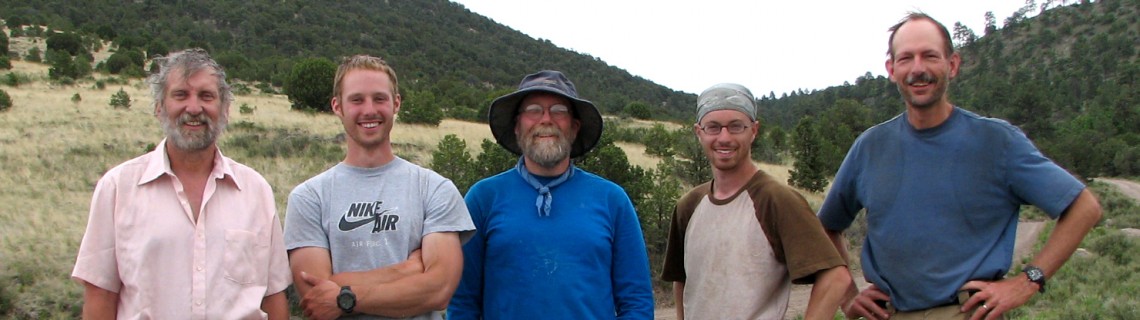
I picked up Matt Eldred at the Albuquqere airport. Young, wiry and fit, from upstate New York, he had just graduated with a Bachelor‘s in Survey Technology. Has hiked all over the Adirondacks. He knew what he was doing.
We circled around to the car rental and met Joe Walker from Connecticut. Joe had finished a tour in the US Air Force, hiking with an army infantry division into Iraq. Joe’s job was to mark targets by laser for fighter jets to strike by missile. Up to any challenge, always smiling, a rock climber, a scuba diver, Joe was earning his degree in Business from the University of Connecticut. He could do anything
We waited for Michael Grosh. He hopped of the shuttle bus, fedora pulled down, silver grey beard, sky blue eyes, trecking poles in hand. This guy hiked in style. Michael is a tug boat captain from Maryland, pushing barges up and down coastal waterways. Fifty, he hikes sections of the Appalachian Trail every summer. Well seasoned.
This was the first any of them had been “out west”. This would not be the great divide I would have liked to show them.
After three hours of driving, from bustling Albuquqere to small town Socorro, to the ghost towns of Old Horse Springs and New Horse Springs we crawled up the gravel to meet Mike Holmes at Valle Tio Vences (Uncle Vince‘s Valley), in the lap of Mangas. Mike had driven his old pickup from northern California. He’s a 20 year Forest Service veteran, the Forest Fuels Officer for Lassen National Forest. He has been on fire crews all over the west. Forty-nine, bearded, he had a companionable fire ready for us as we unloaded our gear and took in the mountain air.
The Valle pushes up towering ponderosa pines that shelter a floor of golden grass. A spring filled a metal stock tank with cool water. Beautiful and serene.
The predawn howling woke us out of that. I was up to catch the golden glow when the vibrating calls hit. This was no coyote. Mexican grey wolves had been released in the area and this one was calling to see who was around. Behind me one answered to report his position. I ran toward the first and closest howl, up the slope, pausing to peer on to the bench. There he was, shaggy grey coat, head down, green eyes making contact with mine. Then gone. We heard them twice more as we breakfasted and packed. Welcome to the Gila.
We drove to our starting point, the mountain’s summit and began a routine. Matt sprung ahead, trecking poles tapping the gravel as he scouted for trail markers, an uncoiled release of energy. Joe effortlessly joined in, his GPS unit locked on to satellites overhead making the official record of our tracks. Michael eased into his well tested, long-trail groove. Mike generally took the rear, keeping a backup track and set of notes. I went back and forth, taking photos and making some conversation. We would spread out, then contract at the intersections, spreading and contracting, for what would become 78 or so miles in six days.
The first day was nearly all downhill, following gravel, then a dirt road. The primary water in this country is held in “tanks”, small check dams of earth placed to block draws, the resulting pond filled with fine clay to keep the volcanic rock from slurping each drop of moisture. Elk, deer and cattle bathe in them regularly. The tanks are thick with mud, and algae, some with minnows and water dogs, all with a certain diversity of microscopic life. Yechh.
Eventually we would be pumping the sludge through filters that would clog after one quart. A tank touted in the guide books looked especially bad. A cow had collapsed at water’s edge, its skeletal grimace turned to the sky in a last plea for mercy.
We noted each tank by coordinates and name. Many held the distinction of G.C. # 1 – 6. G.C.? “Ghastly Cow?” “Green Color”? “Gross Crap?
As the route descended the ponderosas were smaller and were joined by Douglas firs and groves of Gambel oaks. Further down we’d leave the shade behind, moving into a spacious park of pinon pine and alligator juniper, dry grasses and cactus. While the nighttime temps were in the 30’s, daytime sun would bring on high 80’s.
I began to appreciate my companions. Mike lived to prove Murphy wrong, the Murphy of Murphy’s law fame, “Everything that can go wrong, will.” Mike’s mind, step by step, thought of all that could go wrong, and step by step, prevented it. I have always been more of a partner with Murphy, sort of helping things along.
He revealed that he had come the day before and cached water at all of our road crossings. He had packed, and cached, spare batteries by the dozen. Need markers for the maps? “What color would you like?” Highlighters, he had those, too. Rubber bands? “What size? “
On an especially hot day, after we all had been drinking tepid grey water, our mouths tasting of slime, he pulled out a plastic lemon for a squirt of refreshment. I really began to appreciate this guy. I just regret that I didn’t ask him for more odd stuff. What all was in that compressed pack of his, the smallest of all, everything rolled, folded and placed in order?
Toward the end day one, while we rested in the shade, a woman came riding out of the trees, the upright posture and grace of an accomplished rider, leading a mule. She was beautiful and packed a .38 on her hip. This was Erin Zweiner, 21 years old, setting out to be the first person to ride the entire trail in one season. She was a little behind schedule. Her dog was lost. The horse and mule had repeatedly escaped their hobbles at night, hiding through the day, letting themselves be found only at night when they knew she wouldn’t be riding. In a couple of days we would know how they felt. Seeing her determination, I think she has a good chance of making it. (Follow her progress at www.ridethegreatdivide.com.)
The next day brought a long climb, 2000 feet up Waggontongue mountain. An important water source, Damien Spring, had to be located as well. The spring, noted as “the most reliable source of water” in the whole segment, was in a deep volcanic gully off trail, and after seven years of drought was only a worthless trickle. Behind schedule now, the jeep road ended and a small trail began, marked only with blazes cut into the pines.
We came to an old burn with trees like pick up sticks. The trail tread gone, the markings down. We began what was to become the routine. Four guys scouting ahead for any sign of trail, one waiting with the GPS for a call to come on to the next sign. This was not hiking, it was a progressive treasure hunt, going from blaze, to cut log, to cut branch, to blaze. No trail had been built on the ground, just a route marked on the trees 30 years ago.
This hunt continued on, up and down the spine of the Tularosa Range, a range made of bowling ball size rocks, tucked in tufts of grass, all waiting to turn your ankle. Three long days of it. Suddenly a hiker emerged from a narrows, making great time. A through-hiker who didn’t have much time to talk. He noted that another hiker had seen a bear as big as an angus, not far ahead.
Matt continued to keep careful records, drawing each intersection with precision and skill, maintaining a steadiness and discipline at the end of a 12 hour day when I was having trouble putting two words together.
Coming down from a ridge to a crossroad we spotted two men at our water cache. To our relief they were caching their own. Mat Matson of Rotary International introduced himself. At age 69 he is doing a 735 mile through-hike of New Mexico, with plans to do Colorado next summer, then Wyoming and Montana. He is raising money to fund trail crews, 3.1 million dollars to be exact. Matson is passionate about getting young people off their joy sticks and out of doors.
Matson introduced the quiet man at his side, Pem Dorjee Sherpa, a two time summiter of Mt. Everest, who became well known for marrying his wife, Moni, on the summit. He was serving as a sherpa for Matson, carrying 80 pound loads. Pem urged us to come to Nepal, to secure his firm as a guide. He would take us to the Everest base camp. After checking it out, maybe we could climb Everest on the next rip.
Joe glommed on to every word. He never tired. His fun was in challenge. He was only disappointed if we did something an easy way. I think if we had asked him to carry one of us out it would have only made it more fun for him. Huaa!, heard, understood and acknowledged. Joe will love Everest.
The second to the last day we lost the route. We had gone down a draw when we should be up on the ridge. Matt and Joe trotted up the steep slope. There were cairns up there. I was carrying the GPS at this point and went back up the draw to find the turn. I never did. Going out on the ridge I’d locate a cairn but couldn’t see another one. My route on the GPS map looks like one of those spirals the monks walk in to find tranquility. I did not find tranquility. About a 1000 feet below and a mile away the group spotted me and signaled with a mirror. Time to come in, route or no route.
The last day was co-incidentally “National Trails Day.“ It proved to be the most pleasant section, a blazed trail with good tread over O-bar-O mountain, then a long descent through the pinions and junipers. We had seen elk a few times but only as they charged off through the forests away from us. These didn’t hear us in the grass. We were able to get close before the lead cow raised her nose to the air, and got that confused look. I didn’t think we smelled that bad. And then they bolted, flushing two calves out of the junipers to join them.
Plodding on to the vehicles, we realize we hadn’t found Coyote Stock Tank, our official end. Fanning out as scouts, we spied its muddy waters, tagged it into the GPS. Hikers in the future following their GPS screens will go right to it.
There is something about the CDT that does instill big dreams. For the lucky, those dreams stir an inner energy. A challenge is worth doing. Nothing is impossible. The trail that is not yet fully a trail is an Everest in its own way. May crews work on it for the next 30 years. No matter how much work is done, it will never be easy.
To those contests winners who will continue the mapping this summer, I salute you. Crews will come through Wyoming in July.
Few could spare the five months it takes to through-hike. But why not hike a segment? A nice stretch comes through Huston Park in the Sierra Madres, about 2 ½ hours from Cheyenne. It, unlike most of the New Mexico trail, is well marked with plenty of flowing water. You just might get hooked by what’s around the next corner and become a section hiker, finishing the CDT over a life time.
My worries about those strangers? Maybe Shackleton said that best, too. “There are lots of good things in the world, but I’m not sure that comradeship is not the best of them all.”
For lots more photos see:
http://www.flickr.com/photos/54936422@N00/sets/72157600337579194/

Comments
Randy Johnson
May 11, 2009
I really enjoyed this post, thanks for sharing! It brought back some good memories of following badly marked trails and looking for “reliable” water sources in the Rockies. 🙂
Doug Maus
May 13, 2009
I am extremely interested in your GPS data in the short segment from Mangas Mountain south to where the CDT crosses NM 12, as I may be interested in developing, adopting, and maintaining that segment. If you could please email me, that would be great!
Amy
Aug 8, 2010
Great story, thanks for sharing! I’m trying to find more details on hiking the CDT in the Northwestern part of the state this fall; it’s hard to find. Will have to download from Backpacker 🙂
Pingback: books on the continental divide trail | Book info