Huston Park Continental Divide Trail
The information in this piece may be out of date. I have moved away from Cheyenne and am no longer maintaining this site. You may leave a comment if you wish. Useful comments will continue to be posted.
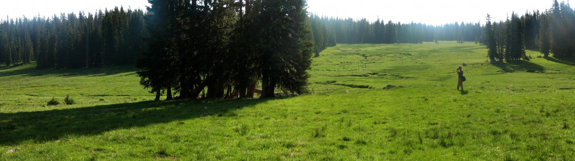
Highlights: This hike is a resplendent walk along the Continental Divide Trail where it weaves together a succession of verdant meadows, each a vast, rich, colorful carpet of wildflowers rimmed with pines, rising and falling along the gentle crest of the southern Sierra Madre Mountain range.
Location: West of Encampment, Wyoming in the Huston Park Wilderness area of the Medicine Bow National Forest.
Elevations: Red Mountain Trailhead, 10,067′; high point, 10,500′, Pipeline Trailhead, 9, 190’/
Distance: Entire trail through Huston Park Wilderness is 13.5 miles one way. The hike is out and back as far as you wish to go.
Maps: Forest Service brochures “Medicine Bow National Forest Continental Divide National Scenic Trail” and “Huston Park Encampment River Wilderness Trail Map”, Medicine Bow National Forest Map, USGS quads Red Mountain, Solomon Creek
Guide:Marc Smith’s Hiking Wyoming’s Medicine Bow National Forest – Third Edition
Trailhead: It is a 148 mile drive from Cheyenne, taking I-80 west to Laramie, exit 311, then southwest on WY 230 into Colorado (where it is CO 127), north on CO 125 back into Wyoming (where it continues as 230 again) to Riverside. At Riverside, turn west on WY 70 through Encampment, continuing 12 miles. Just before you reach the Battle Pass rest area there is a dirt road on the left with a simple CDT marker. With a four-wheel drive vehicle you may want to turn south on this road continuing a rough half mile. With a passenger car, park at the paved Battle Pass pull out.
The Hike: The trail begins on the south side of WY 70 in the forest between Doane and Red Mountains. It is well marked with CDT posts and is easy to follow. You’ll travel along the side of Red Mountain where the trail splits, the right fork leading to Baby Lake. Take the left turn to Huston Park, staying on the CDT, following the old Fireline Stock Drive route. Suddenly the trail emerges into the first big meadow, Long Park.
In early July the meadows are a great sweep of purple elephantheads, dotted with yellow Goldeneye and White Mules Ears. Red paintbrush and blue lupines border in the dry edges. The trail tries to stay high to keep your feet dry but it can be moist and spongey.
From Long Park the trail gently climbs, crossing the headwaters of the North Fork of the Encampment River, over a saddle into the even larger Standard Park. If you continue past the junction of the Roaring Fork Little Snake River trail you’ll reach Huston Park itself.
Huston Park is named for Al Huston. Al came to Wyoming in 1857 when only 17. By the 1870’s he was a rancher, prospector, but most of all a premium hunting guide, leading English noblemen to elk, deer, antelope and bear. He established a permanent camp near Baby Lake. Jim Baker, the famous trapper and scout called Huston, “The one crack game shot of the world, excepting none.” The western slope of the Sierra Madres continues to offer prime elk and deer hunting.
The trail continues along the divide, gradually dropping in elevation until the Pipeline Trailhead, at the end of FS 809, which is off of FS 550 west of Hog Park Reservoir
Pointers: Beautiful campsites can be made at any forest edge. Water is plentiful in the small streams that cross the parks. This is a favorite trail for horsemen, although it is better to wait until August when the meadows are dry.
Four fine trails branch away from the CDT, Baby Lake, Roaring Fork Little Snake River, Verde Mine and Green Mountain, each leading to a Forest Road. Yet making a loop trip in the Huston Park Wilderness is really impossible. The views are so good though that an “out and back” is worth it. A July hike will fill your senses with the color green as you may have never seen it: rich, vibrant, luscious, a living emerald.

Comments
jim conway
Jul 22, 2012
Interesting.
How far in is Baby Lake and is that a good destination for a short backpack??
Roger Ludwig
Jul 22, 2012
I’m sad to say I’ve never been to the lake itself, which I understand is just a small pond. I looked for a user made trail to it once but didn’t find one. The trail is named for the creek flowing from the lake. So, IMHO, Baby Lake is probably not a good destination but the whole Huston Park area is. Just take any of the trails until you find a good place to make camp. I love to set up just in the trees overlooking one of the many parks with hopes of seeing elk and deer in the evenings and mornings. All of the creeks provide water.
Bob(ski) Masson
Jan 16, 2018
So Baby Lake *used* to be a lake, but it was dynamited – I think in the late 60’s. We used to hike in there from Lost Creek Campground (off of WY 70) when it *was* a lake and I was a kid. There’s actually a road now that will take you partway, but it turns and follows the Huston Park Wilderness boarder to the west.
You wouldn’t get to Baby Lake from Huston Park – there’s probably >1K elevation difference (at least from Standard Park) and it’s *really* rugged country. But to answer your question – The Continental Divide entrance to Huston Park (around Red Mountain) will take you to upper Baby Lake Creek, then you can follow it down and come out at Lost Creek. Or you can in-and-out from Lost Creek – it is a pleasant hike – about 6 miles round-trip.
Side note: spent a couple summers trying to find the “Standard Mine” up in Standard Park, which is above the headwaters of Baby Lake Creek. Turns out the USGS Topo maps show you where the claim was filed, but the actual tailings are about 3/4 mile from where it’s located on the map. And Roger is right, it’s beautiful country.
Side-side note – my mom used to drive across the divide there (circ 1940’s) – obviously before it was a wilderness area. There’s still remnants of the old road – and especially the logs that were laid side-by-side as corduroy in the wetter areas in Standard Park. It comes out above Hog Park (I’ve made that hike multiple times – you can start pretty much anywhere – for a short version start at the Green Mountain trailhead of the CDT). Absolutely amazing country.