Greyrock Mountain
The information in this piece may be out of date. I have moved away from Cheyenne and am no longer maintaining this site. You may leave a comment if you wish. Useful comments will continue to be posted.
There are surprises (Wow!) and surprises (Whoa!). On any trip, let’s have more of the first. The Greyrock Trail, not far from Cheyenne, has some solid “Wow’s”, and on my recent foray down from the peak, one definite “Whoa!”.
Driving up the winding Poudre River canyon from Ft. Collins you’ve probably noticed some trailheads. The is the first one. Built by the Civilian Conservation Corps in the 1930’s, improved more recently under the National Recreational Trail system, many people over many years thought this was worth a lot of time and money. It remains very popular and I’ve wanted to find out why.
The trail crosses the river on a footbridge, entering a side canyon that cuts through the granite of the river gorge. It’s a pleasant, rather non-descript trail at first, keeping company with a chattering brook. It climbs steadily but gently.
On the map the route looks like a “pig in a python”. The bridge is the tail and Greyrock Mountain the head. In the middle the trail divides with a bulge to the right and one to the left, the left one having hooves.
In a little while the trail reaches “the pig” giving you a choice of right or left forks. The right one is the shortest so I suppose most take it on the way up, following the other back down.
The right fork leaves the creek and gets steeper, climbing higher than the river gorge. This is the first “wow”. The view behind you, layers of mountains cresting above the canyon, just keeps getting better and better. The Mummy Range crowns it all.
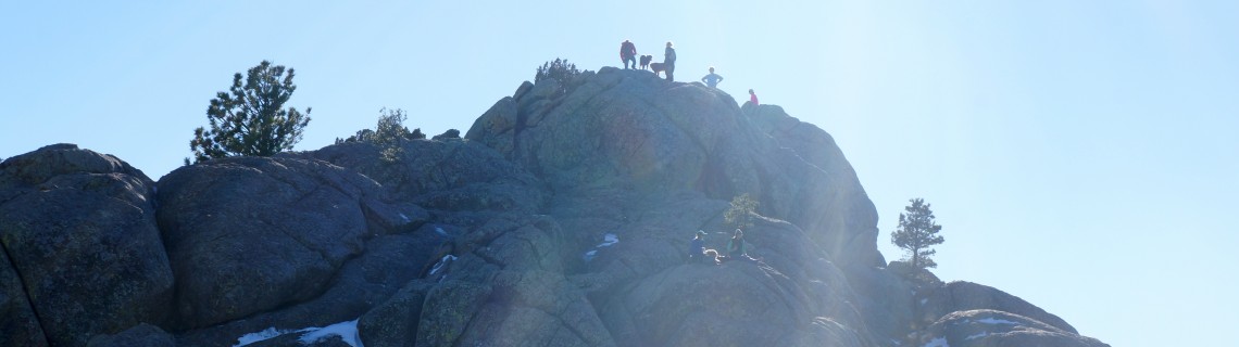
As the trail flattens out Greyrock suddenly appears. From this end it’s a great triangle of granite rising straight up. The two trails around the “pig” join here at its base. A single trail moves along to the right, to the head.
The moderate trail now begins to get difficult. The rough and rocky route makes it’s way up the right side of the mountain. The tread isn’t always clear so keep a lookout for cairns and posts.
As you approach the top you can hear the next “wow”, a chorus of sex-starved frogs calling for company. The top of this granite peak is dished out, holding several large pools, in terraces, shaded by pines. It’s the last thing a person would expect.
On top the route is confusing. Small brown “hikers” signs placed on iron posts mark the best route to the high point on the South end. It’s a hand and foot boulder climb in places. The view, a third “wow”, is immense. The Eastern plains expand to infinity. The windmills on the Wyoming border are clearly in view. To the south, there are canyons and snowy peaks. To the north, the red rocks of the big hole country.
On the trip down, time permitting, most will want to try to other trail, Greyrock Meadows. This is the scenic route, descending into a lush meadow, green as Ireland, another “wow”.
Whoa!
Trying to make it down before night shrouded the trail I was jogging a little. There, right ahead was a furry little guy, not a pig, but with black and white stripes, pivoting on his forelegs, tail raised, and not in salute. I saw the barrel aimed right at my chest. “Whoa!”
Now I’ve been taught what to do in case I meet a black bear, a grizzly or a mountain lion. But I don’t think I’ve ever been given skunk etiquette lessons.
Believe me, I did not stop to ponder the dilema. Full speed felt far too slow. Sniffing the wind, prepared for the worst. Whew, he saved his cartridge for someone else.
The meadows trail winds all around, with a couple of big ups and downs and a long series of hairpins down an open hillside before dropping into the creek bed to join the tail of the trail on its way to the bridge.
Pointers
The hike up and back takes about four hours. It’s 7.3 miles total taking the center loop and climbs 2000 feet. The last .75 mile up the mountain is a challenge. On top, note the point at which you came up so you can find your way out.
The gravest danger here is the poison ivy. The shiny green leaves are reaching out for your ankles for much of the way. Don’t even think about wearing shorts. Long pants and long socks are a must.
Dogs on leads are allowed but with the quantity of poison ivy leave Lady and the Tramp at home. They can get the rash and will also carry the oil on their fur to wipe on you.
Teens would like this trip but it’s too much climbing for younger children.
Getting There
Take I-25 south to exit 278 at Wellington. Follow Colorado 1 west and south, turning right (north) on US 287. Turn left (west) on Colorado 14 heading up the Cache la Poudre canyon. Wind up the canyon 8.1 miles to the parking area on your left, signed for Greyrock Trail.
There are pit toilets at the parking area and a lovely picnic spot just across the foot bridge by the river.

Comments
doug
Jan 24, 2022
Thanks for sharing the beta!