The Gap: North Gap Lake Trail, Sugarloaf Recreation Area, WY
The information in this piece may be out of date. I have moved away from Cheyenne and am no longer maintaining this site. You may leave a comment if you wish. Useful comments will continue to be posted.
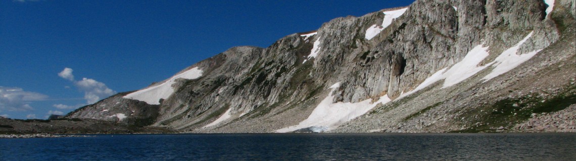
Highlights: It’s the season for a foray into the Snowy Range, the high country of the Medicine Bow. This trail takes day hikers through the gap between Medicine Bow Peak and Browns Peak, past several crystalline lakes into the expansive tundra behind the range. The fish are jumping and the flowers are high.
Location: The high point of the Medicine Bow range, west of Centennial, WY.
Elevations: Trailhead 10,800′, high point 11,120′, Deep Lake10,500′.
Distance: 3 miles each way.
Maps: Medicine Bow National Forest (note the inset); USGS Medicine Bow Peak, Sand Lake quads; Forest Service pamphlet “Snowy Range Trails.”
Guide: Marc Smith’s Hiking Wyoming’s Medicine Bow National Forest – Third Edition
Getting there: From Cheyenne, take I-80 west through Laramie to exit 311. Follow Hwy. 130 west continuing 11 miles past Centennial. Turn north into the Sugarloaf Recreation Area and continue for a mile to the Lewis Lake trailhead. Be prepared for a parking fee and a crowd.
The Hike: The North Gap Lake Trail (#108) begins above the Lewis Lake shoreline with a good perspective of the peaks and Sugarloaf Mountain. Within a quarter of a mile the Lost Lake Trail branches to the east. Stay to the left and begin your gradual ascent to South Gap Lake, nestled against the white quartzize of the range. As you reach the gap the view broadens to the vast lake district left by the glaciers of long ago.
North Gap is below and as you come along side it, Shelf Lakes Trail (#109) departs to the east. This is worth a little exploring. Shelf Lakes 1 and 2 are two of the three Golden Trout locales in the range. The next lake of any size is Shelf 4 which reportedly has better than typical action for brookies.
Back at the North Gap Trail, the path descends through the tundra, passing kumholtz, pines growing horizontally to survive in the howling gales of winter. The Quealy Lake Trail joins on the west just before Cutthroat Lake. (There are only Brook Trout there today.) This trail officially ends at the junction of Deep Lake and Sheep Lake Trail. I’d suggest you continue to Deep Lake, only a half mile further, on trail #110. Deep Lake has good brookie action in the 6″ to 11″ range, according to John Baughman’s excellent “The Most Complete Guide to Wyoming Fishing.” This is the end of the trail, as far as this description goes. As you turn back you have a different perspective on the range and its more gradual north slope.
A glance at the map will bring two good loops into view for those who have time to spend a night at one of the fine lake side campsites. Continuing to Sheep Lake and following trail #389 to Brooklyn Lake, then taking the Lost Lake Trail (#395) is a fine loop, circling Browns Peak and covering about eleven miles total. Another choice, if you want to get a good work-out, is to go down the Quealy Lake Trail to FS 103 to the Dipper Lake Trail and up the north side of Medicine Bow Peak to the summit, then down the mountain to Lewis Lake. The distance is about the same; just add a 1,400′ elevation gain and loss, with a full pack. But what a view!
Pointers: Pray for plenty of wind to take the pesky mosquitos down. Just in case bring plenty of repellent, and sun screen. You may want your flower field guide, certainly a camera. Mountain bikes are not recommended.

Comments
Hiking
Aug 16, 2009
hiking there looks awesome – also love the name of your blog – so relevant