Rock Creek – Deep Creek Trail, WY
The information in this piece may be out of date. I have moved away from Cheyenne and am no longer maintaining this site. You may leave a comment if you wish. Useful comments will continue to be posted.
Highlights: A lovely, long trail following the creeks of a deep, shady canyon. It’s a popular place to stretch out because it’s so easy to get to, so well constructed and the surroundings are so peaceful and expansive. The trail was given National Recreation Trails certification back in 1979 and along with the recognition received funding for lots of neat little bridges. (Since this was written in 2009 the trail has suffered considerable erosion. In places it is quite narrow with steep drop offs toward the creek. Dead-fall is cleared from time to time but there will be some to cross.) The recent Forest Service plan recommends the area be designated Wilderness. An optional spur leads to Crater Lake, a spring-fed gem embraced by towering granite walls.
Location: The northern reach of the Medicine Bow Mountains, near the town of Arlington, 40 miles west of Laramie.
Elevations: Arlington trailhead, 7,920’; Deep Creek campground trailhead, 10,066’.
Distance: 12 to 13 miles from end to end, one way.
Maps: Medicine Bow National Forest; USGS Arlington, White Rock Canyon, Morgan and Sand Lake quads; Forest Service pamphlet “The Snowy Range Hiker.”
Guide: Marc Smith’s Hiking Wyoming’s Medicine Bow National Forest – Third Edition, Bill Hunger’s The Hiker’s Guide to Wyoming
.
Trailhead: To reach Arlington from Cheyenne, WY, take I-80 90 miles west to the Arlington exit (#272). After exiting go under the interstate then turn right, following the sign for “Medicine Bow National Forest.” You will then turn left at the sign for “Rock Creek Trail (FS-127) continuing 1-1/2 miles to the trailhead and parking, no toilet or drinking water.
The Deep Creek campground is on FS-101, which can be reached from WY-130 about four miles west of Centennial or from the Arlington exit by going 1-1/2 miles west on the south service road to FS-111, taking it 13 miles to FS-101, where you turn left and go 1-1/2 miles to the campground.
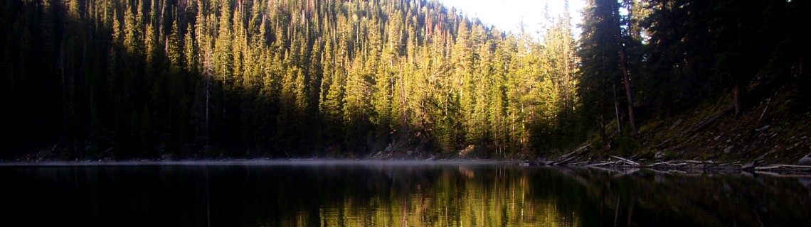
The Hike: I’ll begin at the bottom, at the northern trailhead near Arlington. Rock Creek spreads out broadly here, a sheen of shallow, silver water. The canyon stretches for miles ahead, a deep, broad “V” cut 1,000 feet into the rock. The hillsides are open sage, pierced by rock outcrops; the trail floor soon leads into the shade of a mature aspen grove. Wild flowers and grasses grow thick, rubbing your legs as they seek to hide the trail. A moldering cabin and tailings pile mark the site a of miner’s failed dream. But yours has just begun.
Before long the aspen give way to lodge pole pine, pines which thickly carpet the canyon’s walls for miles. The creek narrows into a long run of rapids, sparkling and laughing below. This is the way it continues, mile upon mile giving hikers a Zen-like tranquility. The trail alternates between forest shade and rocky openings, crossing scree falls of sharply broken rock, amber, gold and rust. Streams rushing toward Rock Creek burst into view with splashing trail-side waterfalls. Hidden in the shade is a rare orchid, the clustered lady’s slipper with its drooping green to brown flower and mottled purple pouch.
The high point to the east is Rock Mountain where a Canada lynx was sighted long ago. Deer, elk, mountain lions, and bear are more common. Boreal owls haunt the forest. The creek hosts rainbow and brook trout.
After 4-1/2 miles the canyon forks and the trail stays to the west, now following Deep Creek. A short way further an unmarked snowmobile trail cuts off to the right, no longer maintained, heading up onto the ridge top through groves of aspen and open, dry meadows.
About 2/10 of a mile further on is small creek and a trail leading up the hillside to Crater Lake. The junction is marked by two signs but one is misleading. It reads “Crater Lake 2 miles.” The lake itself is 1/3 of a mile. It is 2 miles to the trailhead beyond it. Here’s a tough choice. You can continue along Deep Creek as it begins to widen and open through wet meadows frequented by moose to the trail’s end at Deep Creek camp ground and FS-101, or take the steeper trail as it wiggles upward in tight switchbacks 425 vertical feet up to Crater Lake. Or you could do both.
Crater Lake was not formed by a crater, although it looks like it. It’s a “hanging lake,” left by a receding glacier long ago. Fed by springs, the lake is deep and clear and is held in a tight embrace by curving walls more than 200 feet high. There is a lovely campsite near the lake shore. The trail continues along the shoreline to the north and ascends the walls to FS-113 high above. Many visitors come down to fish for pan sized brookies and to enjoy the scene.
Pointers: This hike makes a nice overnight with a stay at Crater Lake or at one of the many campsites by Rock Creek. With friends, and a car at each trailhead, you can enjoy a long descent or an uphill challenge. Many will just trek as far as they like and turn back. Or this could be the first leg of a longer backpacking trip, crossing the road near Sand Lake and continuing on Sheep Lake trail 8.2 miles through the Snowy Range roadless area to Brooklyn Lake, then following the road to the North Fork trail and 4.4 miles more to North Fork Campground.

Comments
Darcy Gardiner
Oct 23, 2009
I work at Biodiversity Conservation Alliance in Laramie, WY, an environmental conservation group. We have been looking for a nice picture of Rock Creek to put on a T-shirt as a fundraising thank you gift (premium) as we are a primary organization advocating to give the Rock Creek area Wilderness status. I came across your blog looking for pictures and especially like the one with the reflection. Would you be willing to give us permission to use your photo if we give you a photo credit for it? Thanks, Darcy
Roger Ludwig
Oct 23, 2009
I’d be honored. I’ve been a member of your Alliance for several years. After visiting Adobe Town I began looking for an organization working to preserve it. BCA had been on it for some years. I appreciate your efforts on behalf of the Medicine Bow as well. I’ll email you a copy of the Crater Lake photo that may be better resolution than this web version.
Best wishes.
JD Ruhter
Jul 27, 2010
I hiked down from Sand Lake 2 weeks ago and stayed at Crater Lake. Thank you for the information on how the lake was formed, we have been wondering that for several years now. The next morning we hiked the rest of the way out to Arlington. I have hiked hundreds of miles of trails in the Medicine Bow and so far this was the best hike of them all. We are going to hike the trail again this weekend and plan on spending much more time fishing. This trail far exceeded all of our expectations and I can’t wait to hit it again.
Dan
Sep 1, 2010
Thank you for the very brief information about the Trail. My friend and I have been thinking to go there one of these days and this information is very helpful in our planning.
Cody Cast
Jun 24, 2013
WOW! What a hike! Me and a buddy planned to make this hike from Arlington to Crater lake; stay the night and push on to sand lake in the morning. This trail is definitely not for the fate of heart. We trucked in 8 miles and boy were we exhausted! We found a sign and that said Sand Lake 5 miles and there was a fork in the trail heading steeper into the forest. We took it for about a mile and it was rough. Climbing over tons of down trees. We were hoping it was the trail to crater lake. However there was no sign to tell us if it was the right trail. We couldn’t push on any further plus it was getting dark. So we turned around and went back to the main trail and made camp for the night! Didn’t get to sand lake over slept till about 11am so we just packed up our 50lb packs and heading back to Arlington! Gosh it was night to sit in some air conditioning for a minute before heading home!! Definitely will try this trail again!
Roger Ludwig
Jun 25, 2013
You were almost there but made the mistake of turning onto the old snowmobile trail. I call it the “orange over silver” trail because it is marked with colored metal squares nailed onto trees. 2/10th of a mile further south is the Crater Lake Trail. Two signs note it right where a small creek crosses the path. The Crater Lake Trail is the “grey diamond” route, marked with plastic grey diamonds nailed to trees.
The downed logs and trail erosion make this whole trip harder than it once was. With beetle kill and cut backs to the forest service budgets it looks like that is going to be the way of things for years to come. Thanks for the comments!
Dan Omlor
Jul 12, 2014
My wife and I hiked the Rock Creek – Sheep Creek combo from Arlington to Lewis Lake Campground. We are avid backpackers and run an adventure travel website, OutpostUSA.org, so we’ve seen trails from the Grand Canyon to Glacier Park to the Smokies and Adirondacks. This is definitely one of America’s Top 10 Trails and may be our favorite. We stayed over at Crater Lake and Sand Lake an extra night each to explore the area and fish. Wonderful country. The highlight of the trip may have been sighting a Black Footed Ferret between Deep Creek CG and Sand Lake. They’re not supposed to live there. We turned photos and coordinates over to the rangers and to the UW Wildlife Biology folk back in Laramie. I’m from Dubois and know the Wind Rivers well and they’re spectacular but no trail up there beats this one.
Roger Ludwig
Jul 12, 2014
Thanks for your comment. Glad you had a fine trip. Many don’t see the Medicine Bows as a multi-night backpack destination because of the number of intersecting roads. What a good plan you made, to put together two of the big attractions, Rock Creek Canyon and the high lakes country, with only one Forest Service Road to cross. Do you have any comments for the writer who had trouble finding the turn off to Crater Lake? It has been a few years since I’ve been there. Enjoyed perusing your site, OutpostUSA.org, especially the Big Bend National Park write up, a place I’m eager to see. Roger
Katie Kern
Sep 15, 2014
Just did this hike this past weekend and it was amazing! We shuttled cars and started from the Crater Lake parking lot and worked our way down the trail to Arlington. We stayed overnight about 7 miles down where there is an old cabin and a great camping spot. We had a few downed trees to climb over, but later in the day a trail crew came through with their chainsaw and cleared the trail, which made our hike out on Sunday much easier. We even had a group of mountain bikers pass our campsite heading toward Sand Lake. My friend caught quite a few fish along the way and the views were unbelievable. Definitely would do this trail again!
Candice Larsen
Dec 1, 2024
Roger. I have ordered the book There’s Treasure Inside by Jon-Collins-Black. The author has hidden 5 Treasure Boxes across the country. One such box is the Forrest Fenn Treasure named after the Fenn Treasure hidden and found in Yellowstone. There is a poem on page 210 describing where the Forrest Fenn Treasure Box is hidden. I believe the clues could be leading to Rock Creek Trail, but I am not that familiar with the area. A couple lines make me think it could be on the trial. “pass by the place where once was Brown” “The compass points now towards the home of point and tree and seeing eye.” Place that once was Brown? Ephraim Brown, killed in 1857 on the trail at Rock Creek near South Pass. Home of point and tree and seeing eye could be the old miner cabin in the Aspen Grove. Aspen trees often have “eyes” on the back. There is more in the poem that I feel could match up with this location. I would like to see what you think, since you know the area we’ll.
Roger Ludwig
Nov 2, 2025
Candice – sorry it has taken me so long to get back to you. I hadn’t checked the comments for a long time. This Rock Creek is a long way from South Pass. I got caught up in the Forest Fenn treasure hunt for a few weeks. It can be a dangerous obsession. Interpreting the clues is tricky. We all have a tendency to bend the clues to mean what we want them to mean. If you haven’t seen it be sure to watch the Netflix movie “Gold & Greed: the Search for Forest Fenn’s Treasure.”