Sycamore Canyon Wilderness, Arizona: Taylor Cabin – Casner Mountain Loop
The information in this piece may be out of date. I have moved away from Cheyenne and am no longer maintaining this site. You may leave a comment if you wish. Useful comments will continue to be posted.
Bad info
Have you ever taken a long hike with bad intelligence? That was our situation hiking the Taylor Cabin Loop in Sycamore Canyon, Arizona,late March, 2012. Our little group relied on trip descriptions that led to false expectations, frustration and some tense moments.
The books we were using were A Guide to Northern Arizona’s Greatest Hiking Adventures by Bruce Grubbs and Arizona’s Wilderness Areas by Tom Dollar as well as the Forest Service “Sycamore Canyon Wilderness” map, 2002.
I hope this may correct some misunderstandings so that your party can have a better time in what is truly a wonderful wilderness.
First, the trip
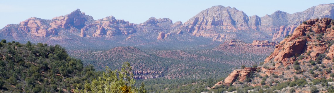
Sycamore Canyon is a broad, long canyon west of Sedona, Arizona. Often compared to its famous cousin, Oak Creek Canyon, because it similarly cuts through the Mogollon Rim, it is really quite different. It is much broader, seven miles wide in places, giving it a different feel. And there is no flowing creek at its core. Sycamore Creek is seasonal, dry during much of the year, except at its end at Parson’s Spring. And wilder! The first wilderness area designated in Arizona (1984) and prior to that the first designated primitive area (1930’s!).
This is the first time I’ve wondered if a wilderness area could be too wild. With the thick brush in places it can be tough to get around off trail. And on trail? Some of the trails get so little use they can be hard to find.
The Taylor Cabin Loop is a about a twenty mile hike best viewed in three parts:
1st, from FS 525C under the power line to the Dogie Trailhead, over Sycamore Pass down to Sycamore Creek and across it.
2nd, up to the Sycamore Basin trail, hike north to Taylor Cabin, passing it to the junction with Taylor Cabin Trail at Sycamore Creek
3rd, ascend Taylor Cabin Trail to Casner Mountain Trail following it up and along the ridge, over Casner Mountain and down to the vehicle at the power line.
Mileages are estimated at seven miles, then five miles, then eight miles. We did it in 2 ½ days, starting at noon and ending at five.
Day one over Sycamore Pass and down to the creek we found to be pleasant, walking in a juniper forest with openings for canyon views and sightings of the lovely “Schnebly Hill Formations”, the smooth red rock that the area is famous for. It does seem like the trail goes on and on before dropping to the creek. It finally does.
There are great campsites on both sides of the creek. We liked ours on the west side yet still within the inner canyon.
Day two was more scenic, out in the open. The cuts down into the side canyons and out were fun and beautiful. Taylor cabin is great, a marvel of rock construction and preservation, and the setting in lovely.
Beyond the cabin to the Taylor Cabin Trail turn off was miserable. Rock hopping was strenuous. Bush whacking was lacerating. Zeroing in on the junction was stressful. But we found it and camped on the sand banks of the creek–soft, cool and comfortable.
Day three was the big climb: 1,850 feet to the ridge, another 500 feet to the top of Casner Mountain. The trail starts right in the creek bed, then cairned routes take you back and forth to avoid pour offs. The canyon has many huge pines reaching far down in altitude. Great oak woodlands.
Climbing out was surprisingly fun but required careful route following, keeping to the right hand forks, then traversing out of the creek bed along the canyon side.
Views from Casner Mountain are wonderful, first down into Sycamore Canyon and then looking down at the gorgeous cliffs of the Red Rock-Secret Mountain Wilderness. But the jeep trail is rocky and makes for a long hard walk under the power lines. Thankfully the lines don’t hum and buzz.
Switch-backing down the mountain is tough on knees and longer than it looks!
Issues
Water. The general desert hiking rule of thumb is a gallon a day per person. We, hiking in March, found plenty of pools in Sycamore Creek. But no water anywhere else. So we needed two quarts walking in, two to walk section 2 and three to walk leg 3. Camping at the creek we pumped plenty of water for breakfasts and dinners. No problem.
Reading other’s posts I saw that many hiking a little later in the season found no water in the creek. Done over three days like we did would require two and ¾ gallons, probably more than anyone would comfortably carry.
What then? Cut the hike into two long days probably, carrying 1 ½ to 2 gallons each. Or carry a gallon and if the creek is dry spend the night and hike back out the way you came.
Location of Taylor Cabin. The cabin is NOT on the west side of the trail as marked on the Falcon Guide map. It is on the east side, and in fact is not on the Sycamore Basin Trail at all. Take a spur trail about a tenth of a mile down to it, then to the corral and on to the creek and some lovely pools. There is a sign at the junction to the spur trail but we found the trail numbers to be unclear.
The coordinates for the cabin are: 34°59′ 19.92″ / 111̊° 59′ 13.08″. Elevation: 4,412′.
If it is only 3 miles to the cabin from the junction of the Dogie Trail and the Sycamore Basin Trail it is a very long 3 miles, in and out of two or three side canyons. It felt like more than 3 miles, but who knows….
Location of Sycamore Basin Trail junction with Taylor Cabin Trail. This critical point is where you must turn to climb out of the canyon. The books say it is between 1.8 and 2.0 miles from the cabin.
From the cabin you go back up to the Sycamore Basin Trail and head north. Soon the trail becomes very hard to follow, perhaps impossible. Much of the area is heavily overgrown with scratchy yew. We wish we had worn long-sleeved very light weight shirts as we were all a little bloody by the time we reached the junction.
The books (and map) say to stay on the west side of the creek if possible, follow the creek if you have to. In reality a cairned route crosses the creek a few times. Try to follow the cairns.
You may want to look this up on Google earth. Zooming in closely Taylor Cabin is visible and the trail to the north is clear with some of the creek crossings visible. I wish I had looked at it and drawn them in on the map.
We did come right to the junction. At that point there are two posts with old signs boards that have no remaining writing on them marking the north and south entrance to the Sycamore Basin Trail. There are good sized cairns on each side of the creek.
From the Taylor Cabin Spur trail I set a GPS and found that the distance to the start of the Taylor Cabin trail out of the canyon was 1.34 miles as the crow flies.
The coordinates of the junction are: 35°00′ 09.6″ by 111̊°58′ 06.1″ (NAD 27). Altitude 4,536′.
(I can see why there is an advantage to hiking the trail in the reverse way, climbing over Casner Mountain, then down Taylor Cabin Trail. This way you can’t miss the junction. You would need an early start to the day and be certain there is water in the creek bed or carry 1 ½ to 2 gallons and do it in two days.)
Signs. As a designated wilderness area no new signs are placed. The old signage can be a little confusing and doesn’t always follow the numbers on the Forest Service Map. Note that the Taylor Cabin Trail (35) doesn’t reach Taylor Cabin but joins the Sycamore Basin Trail (63) to get there. Some signs for trail 63 designated it 66.
Since this whole area gets little use and probably no trail maintenance the trails are growing fainter. Careful observation is a must!
Conclusion. So remember these things: Have the right amount of water. Take long sleeved, light weight shirts. Update your map, planning on crossing the creek bed after Taylor Cabin. A GPS with way-points loaded in may give some security.
If this is helpful to you please let us know. It’s a great hike in a very wild and wonderful canyon.

Comments
Mike
Jan 3, 2014
Great article we went early on no water except rancid pool couldn’t find trail up mountain after the cabin lol turned around after 3 hours of rock hoping(sucked) going to try again in March this article May help do u have GPS of turn off up casner after cabin? Would appreciate it thanks
Mike
Oct 13, 2014
Same here! We just hiked the trail and turned around in fear of running out of water. I recommend spending a night at the cabin and scouting the trail entrance for at least a few hours early in the morning. After reading this article we realized the trail is right at the base of a large bute and sandy beach. Oh well, next time! Big thanks to the stone stacker!
Mitch Stevens
Nov 9, 2015
Hi Roger,
I was looking for some information on hiking this morning when I came across your excellent resource page. I have hiked in the Sycamore Canyon Wilderness on several occasions; what a beautiful place!
What a fantastic list of hiking resources!
I actually just published something on hiking:
http://southwestdiscoveries.com/benefits-hiking-15-tips-jump-start-path-longevity-today/
It might make a good fit for your page.
Either way, keep up the awesome work!
Cheers,
Mitch Stevens
Nate Dawg
Mar 14, 2017
Took Packard Mesa Trail->Basin Trail->Cabin Trail->Mooney Trail. Stellar hike needing basic orienteering skillz and a fat sack of smokeable treats. Filter yer water and keep an eye out for Spanish treasure.
Russ Dryer
May 14, 2020
This is a realistic account of the experience you are likely to find in much of this Canyon wilderness. Add to the difficulty of getting good intel by trying to use a Coconino County Forest service map where no road number on the map will you find to correspond to the reality on the ground (in your effort to find any trailhead around this canyon). We did the Dead man Pocket trail— Beware: there are two Dead man Pocket trails that start from trail heads that are 5 miles apart but accessible from very different routing tens of miles apart in origin, one from the North near Williams and one from the South below the Drake Rd.