Backpacking 101 + 2 great trips: South Inlet in RMNP and Crater Lake in Indian Peaks Wilderness
The information in this piece may be out of date. I have moved away from Cheyenne and am no longer maintaining this site. You may leave a comment if you wish. Useful comments will continue to be posted.
Would you like to try backpacking? Wild, the best-selling memoir and movie starring Reese Witherspoon, has put many people in a backpacker’s boots–in imagination.
But are you wondering “Could I do that? Would I want to do that?” For some there is an emphatic “No way! What was I thinking for that nano-second?!” But if wondering lingers, if you can see yourself awakening in a sublime mountain meadow, dew glistening, backpacking may be for you. Here are some things I’d like you to know.
First, it doesn’t have to be that hard. While the author of the book, real-life hiker Cheryl Strayed, did some great planning with food, she really could have used some help with shoes and gear. Especially shoes. A day’s backpacking will leave you tired, hopefully with the satisfaction of real accomplishment. But you do not have to be in excruciating pain.
If you like the outdoors and are reasonably fit (or could get that way with a goal ahead of you) and the idea of being self-reliant appeals, read on.
Why backpack?
Those of us who do are looking for renewal: physical, mental, emotional, social. That extra time in a wild and breathing world can bring us back to natural rhythms, to our partners or families and to ourselves.
There is the pulsing night sky, bright with the Milky Way. Sunset and sunrise bathe the world anew in ethereal light, reflected in the stillness of crystal water. There is no sound but a gentle breeze in the trees, the fall of water over rock. With the essential gear on our backs we can go further, gaze into splendor that very few will ever see.
There is the endorphin high of Rocky Mountain exertion, the satisfaction of miles covered, the smell of fresh coffee, conversations that may just never occur otherwise.
No one has said it better than John Muir, the patron saint of backpackers. “Climb the mountains and get their good tidings. Nature’s peace will flow into you as sunshine flows into trees. The winds will blow their own freshness into you and the storms their energy, while cares will drop away from you like the leaves of autumn.”
The peace he wrote about in 1894 can still be found, just a mile down a dirt trail.
Perhaps Cheryl Strayed’s story in Wild, while intriguing, has scared you away.
What I wish Cheryl had known
Many books have been written to tell people how to backpack. Any one or two recent ones are worth looking over. Yet all you really need to know is that it is walking with all the necessaries on your back, all that you have to have and not an ounce more. And that shoes may be the most important thing. It’s hard to have your head in the clouds when your feet are in the fire.
Good hiking shoes or boots are well ventilated with engineered fabrics that are water proof. The soles grip and are solid enough to protect your tender feet from sharp rocks. They should fit you right in the store. And “right” means that you are wearing a thin pair of nylon wicking socks to pull away moisture, and a medium pair of wicking socks for cushioning. The boots shouldn’t slip in the heel but have enough room in the toe area for some foot swelling. The adage “a pound on your feet equals five on the back” has military science behind it. So go light, with low or mid-height shoes.
After that all experienced backpackers work from a check list. Forgetting an essential can ruin a trip. The thought conversation we have while packing is different from a road trip. Instead of “might I want this” it is “do I have to have it to survive.” Here’s the list that my family works from for a Rocky Mountain hike:
Essential Gear
Backpack, internal frame preferred, capacity from 3000 to 4000 cubic inches
Tent (to be shared)
Sleeping bag, down is best, warmth rating ten degrees colder than you expect
Sleeping pad, for insulation from the ground and comfort
Rain cover for pack
Water purification tablets (like Potable Aqua Plus) or water filter (shared)
Stove, fuel canister, pot and lid (shared)
Plastic lighter
Bowl, plastic spoon or spork, plastic travel mug
Pocket knife or multi-tool (shared)
Two quart water bottles
Washcloth
Headlamp with extra batteries
Mosquito repellent
Sunscreen
Tooth brush, tooth paste, camp (biodegradable) soap, comb or brush
Prescription medicines or vitamins
Plastic trowel (shared), toilet paper in a baggie, hand sanitizer
Map (shared)
Signal whistle
Emergency Equipment (Shared)
A few feet of grey tape
A few feet of cord
Space blanket
A few first aid supplies
Clothing (*worn on hike)
Nylon pants that will dry quickly*
Wicking T-Shirt*
Lightweight long-sleeve shirt*
Sun hat*
Undies, sock liners, wicking socks*
Hiking boots*
Sun glasses*
Warm fleece or down sweater for evenings
Warm fleece or wool beanie
Long underwear
Rain/wind jacket
Rain pants
Extra pair of undies & socks
Extras if you want
Camera
Paperback book
Writing pad & pen
Trekking poles
Mp3 player
Playing cards
Food
Here are some simple possibilities. For breakfast: dried fruit, granola, coffee or tea. For lunch: tortillas or bagels, string cheese, salami or a tuna salad pouch. Toss in some single serving condiments from a convenience store. For snacks: snickers, granola or power bars. For suppers, most of us start with Mountain House pouches (available in the camping section of Walmart), one pouch per person. Just pour boiling water into the foil bag and you have hot food. Gatorade powder mix can keep you hydrated. It is useful to portion your food out into baggies in the comfort of your livingroom so you have enough but not too much.
But what you most need is an exciting destination
If I were to recommend a first backpack adventure, probably two nights out, I’d want a few things. First: a spectacular end point, about a seven-mile walk away. Second: an interesting and exciting trail that offers a lot to see along the way. Third: good day hiking from the campsite. Fourth: not too far from Cheyenne.
I’ve picked two. One allows dogs, an essential companion for many, the other does not but will give hikers a better chance to see wildlife. Both of these hikes are in reservation-only areas, which have an advantage in that you know it will not be too crowded and that there will be a site for you. Of course there is the small hassle involved in making the reservation.
East Inlet trail to Lake Verna – 6.9 miles
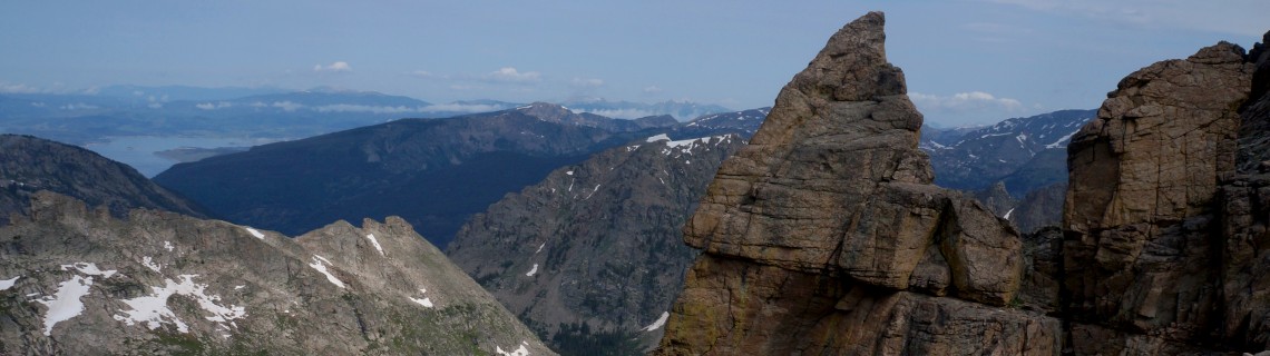
This backpack takes you by a series of five wonderful lakes, each a beauty queen contestant. The trip starts with a bang, Adams Falls, a rush of water in a big rock box. A peaceful broad wetland popular with moose follows. There is an uphill section leading to the first lake, Lone Pine, and then the others follow, each with a backdrop of inspiring granite. The trip ends with the spires of the Continental Divide.
One of the best camps is above the second lake, Verna. I’d suggest you spend two nights there with a day hike adventure the second day. Most will want to follow the cairns up to lake three, Spirit Lake (my favorite) and beyond to Fourth and Fifth Lake (yes, that really is their names) high in the rocks. Or if you are very adventurous there is an old path up to Boulder-Grand Pass on the divide.
East Inlet Trail is in the southwestern corner of Rocky Mountain National Park not far from the town of Grand Lake. To plan your trip, start with a map. “Rocky Mountain National Park” by Trails Illustrated is a good one. You may want a guidebook. Rocky Mountain National Park: The Complete Hiking Guide by Lisa Foster is superb and will whet your appetite for years to come.
If you go:
Choose your dates, probably between the second week of July through the second week of September for best weather. Download a “Backcountry Camping Guide” from the Park Service at: www.nps.gov/romo/planyourvisit/backcountry.htm. Within it is “Trip Planning Worksheet.” This is your reservation request. Complete it and mail it in. The best sites for this hike are 068 Lake Verna or 067 Upper East Inlet. If there is availability you’ll get a reservation in the mail.
Rocky Mountain National Park regulations require use of a bear canister, a plastic bear-proof cylinder to store food. They can be rented by the day from any Estes Park or Grand Lake sporting goods store. The rangers will check to see that you have one.
The morning of your trip, between 8:00 and 10:00 am (after 10:00 your reservation can be given to someone else!), pick up your actual permit at one of two ranger stations, either Beaver Meadows Visitor Center on Highway 36 west of Estes Park, CO or at the Kawuneeche Visitor Center on Highway 34, north of Grand Lake, CO. You will pay $20 for the permit, no matter how many people or how many nights. At the visitors center a kindly ranger will brief you on current conditions, park rules and will give you a detailed map of your camp site.
To drive to the trailhead you can go via Estes Park, pay your auto fee to cross the park on Trail Ridge Road, and leave the park on the south west side. The trailhead is actually outside the park near the end of West Portal Road in Grand Lake, Colorado. Or you can take the way through Laramie, south on WY 230 through Woods Landing to Granby, then east on US 34 through Grand Lake to the Kawuneeche Visitor Center to get your permit. This way is longer but you will avoid the park fee and traffic.
Cascade Trail to Mirror Lake and Lone Eagle Peak – 7.5 miles
This splendid backpack is in the same general neighborhood but is south of the Park in the Indian Peaks Wilderness. And the general plan is the same, following a stream to its source along the Continental Divide. On this one you can bring your dog.
It begins with a great start, along the side of beautiful Monarch Lake, then ascends along Cascade Creek, named because it is one lovely waterfall after another. The prime destination is a pair of lakes, Mirror and Crater. Mirror Lake reflects the impossibly perfect triangle of Lone Eagle Peak. Just beyond is Crater Lake in a bowl of towering mountains. There are fine numbered camping sites all around the two lakes.
For your second day you may want to move camp to Pawnee Lake, about a mile back the way you came and a second mile up Pawnee Pass trail. Or you may just want to leave camp at Crater and day hike up to Pawnee. This lake is also magnificent, tucked into a backdrop of classic Rocky Mountain summits. As a day hike you can ascend the steep trail to the top of Pawnee Pass and stare down into the lakes of the eastern slope.
On the way back to the trailhead you can circle the other side of Monarch Lake and inspect an old steam engine that powered a mining operation.
If you go:
Get your map, Trails Illustrated “Indian Peaks Gold Hill.” For a guidebook I recommend the classic Hiking Rocky Mountain National Park Including Indian Peaks by Kent & Donna Dannen. It too will prime you for years of wilderness adventure.
Pick your dates, again mid-July through September. Get a permit application online at www.fs.usda.gov/detail/arp/passes-permits. Mail it in, requesting Crater Lake Backcountry Zone or Cascade Creek Backcountry Zone for Pawnee Lake. Entry and exit trailhead is #200, Monarch Lake. Include a check for $5. You will get a permit in the mail.
Sites at both lakes are first come, first served.
No bear canister is required. Campfires are not allowed at Crater Lake but are at Pawnee if you are 100 feet from the lake or creek. Mosquitos can be especially bad at Crater Lake if the wind is down.
To reach the trailhead go south from Grand Lake on US 34 turning east on County Road 6. Continue on 6 until it ends, 9.6 miles. (Or north from Granby on US 34 5.4 miles to CR 6.)

Comments
Grainne
Apr 12, 2015
This is a great post! My husband and I are moving to Colorado later in the year and are really excited to begin backpacking!