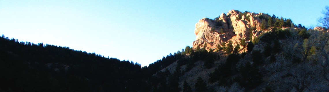
Arthur’s Rock at Lory State Park, Ft. Collins, CO
The information in this piece may be out of date. I have moved away from Cheyenne and am no longer maintaining this site. You may leave a comment if you wish. Useful comments will continue to be posted.
Highlights: A fine spring hike to summit the granite crag overlooking Horsetooth Reservoir, Ft. Collins and the endless plains. During a moist spring, wildflowers are abundant.
Location: West of Ft. Collins, CO, about 50 miles south of Cheyenne, WY.
Elevations: Trailhead, 5,600’, Top of the Rock, 6,780’.
Distance: 1.7 miles one way
Map and Guide: “Colorado State Parks: Lory” pamphlet. The map and fine trail descriptions are also online at http://parks.state.co.us/Parks/Lory/Trails/LoryTrails.htm
Trailhead: Take I-25 south from Cheyenne, exiting at Wellington. Follow Colorado 1 west and south, making a right on N. College (US 287). In just 1 ½ miles go straight to Laporte. (From here you can follow the “Lory State Park” signs except for the last turn. That sign is gone.) Turn left at Vern’s Liquor (52E), then left at the Bellevue Store (23) then 1.4 miles and right on 25G. Continue 1.6 miles, turning left into the park. After paying your entrance fee at the visitor center continue south through the park to the last picnic area.
The Hike: This popular trail enters a narrow cactus and yucca strewn rocky gulch. It’s a gateway into another world. The little canyon opens to a broad swale of grass rimmed by stately ponderosas. Arthur’s Rock towers above like a crenellated battlement, guarding the grounds. The well built trail follows several switchbacks, easing the climb.
Crows, magpies and squirrels make a fuss as you continue up. The desert seems far behind as hikers take comfort in the shade of the great pines and junipers. A few trails branch off but every junction is as well marked as any you’ll ever find.
As you come to the rock you’ll find the route leads straight up a steep, rocky draw for the final 1/10 mile. Gasping for breath, hikers earn the right the stand on the top.
The craggy pink granite offers a broad summit on which to look out over the blue waters of Horsetooth, past the great hogbacks and the city of Ft. Collins to the eternal plains. To the south is Horsetooth Rock, standing about 500’ higher.
If you have time and energy the Timber Trail beckons, leading from the base of Arthur’s up the ridge line into, you guessed it, the timber.
Pointers: Entrance fee is $6 per vehicle. Pit toilets and picnic tables are available at the trailhead, water at the visitor’s center. Dogs, on leash, are welcome.
Lory State Park is a gem with 2,400 acres and 20 miles of trails. If that is not enough, Horsetooth Mountain Park adjoins on the south with 2,711 more acres and 29 trail miles. Some, like Arthur’s, are for foot traffic only. The others are open to mountain bikes and horses.

Comments
Mark Stella
Apr 17, 2014
Arthur’s Rock is very nice, but a popular destination in the park. The West Ridge Trail will take you through some very nice forest and get you on a ridge behind Arthur’s Rock where the views are equally as nice and fewer people.