The Angel at Devils Gate
The information in this piece may be out of date. I have moved away from Cheyenne and am no longer maintaining this site. You may leave a comment if you wish. Useful comments will continue to be posted.
Highlights: This short hike is long on attractions: interesting geology, abundant moose and beaver, boiling brookies, but most of all, fascinating archeology.
Location: In the southern Snowy Range, west of Foxpark, entering the Platte River Wilderness
Elevations: Official, four wheel drive trailhead, 8,850’; Douglas Creek:7,950’.
Two wheel drive trailhead on FS 580, 9,188’; Douglas Creek:7,950’.
Distance: From official trailhead, 2. 8 miles each way. From FS 580, about 3. 8 miles each way.
Maps: Medicine Bow National Forest, “The Platte River Wilderness” free Forest Service pamphlet, USGS Quad Elkhorn Point
Trailhead: From Cheyenne, Wyoming take I-80 to Laramie, take exit 311, following WY 230 southwest to Foxpark. Turn right on FS 512. After crossing Douglas Creek stay on 512, making a sharp right. Two wheel drive or low clearance vehicles should turn left on FS 580, continuing until the junction of FS 514. Park at the junction. Four wheel drive, high clearance vehicles can continue to FS 506. Turn left and follow this rutted narrow road to 506D. Turn left again, continuing about ½ mile to the Devil’s Gate Trailhead.
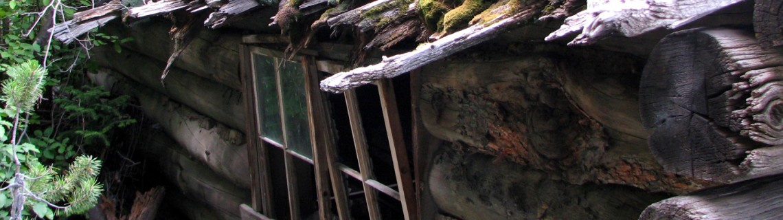
The Hike: After signing in at the register, follow the trail down the east fork of Devil’s Gate Creek. The trail is often moist and sprinkled with columbines and arnica. Four short posts mark the wilderness boundary. Beavers have created a series of ponds, forming mirrored terraces teaming with brookies. At the last dam you’ll spot the remains of Thomson Lodge to the left, two long, low cabins connected by a roof over the patio.
The Lodge was operated into the 1950’s by Edith “Bobbie” Thomson, known as the “Angel of Keystone” for her service as nurse, postmistress, cook and teacher to area tie hacks and their families. It is made from tie hack cabins, two of very few with some roof remaining. In one you’ll note a log book where hikers and hunters have left their comments over the years, many noting the serenity of the setting. Add your impressions.
Also at the last beaver dam, to the right of the trail, is the start of what might be the most impressive remaining construction of the tie industry era, the long Carbon Timber Company flume which floated ties down to Douglas Creek and out to the North Platte. The flume, built between 1900 and 1906, follows the East Fork, then cuts across to the West Fork, plunging down to the confluence. Imagine the hundreds of men that sweated and swore, filling this now peaceful hollow with thunder. The lodge area was once a small, booming village.
Past the lodge the trail crosses over to the west fork also, below the flume, continuing down to Douglas Creek. Time to turn back to the Lodge and trailhead.
If you are using the passenger car trailhead, begin your walk down narrow FS 580 into the pines. At the first junction take 580. 07. After a pleasant, cool mile you’ll come to the east fork of Devils Gate Creek. Turn left. Shortly you’ll arrive at the register mentioned above.
Pointers:So where exactly is “the Gate”? The creek was named long ago, in the era of the mountain men. My guess is it’s the rock formation on the east fork just above the west fork junction. What do you think?
Access to Thomson’s Lodge can also be gained by hiking down Douglas Creek from Pelton Creek campground to Devils Gate or by hiking up Douglas Creek from Pike Pole campground.
On my last visit, I was crouching down below the dam to clean my limit of brookies in the early evening. When I quickly stood up a beaver cracked his tail so hard and fast on the water I thought for sure I had been shot. It startled a cow moose, black as night, standing just a few yards away.

Comments
Antony Cox
Aug 19, 2016
My name is Tony Cox. I came across this post and I found it very interesting. I was drawn in with the history of the logging industry there and the woman named Edith Thomson. I have been digging around online for more information about that woman who was known as “Angel of Keystone” and I can find VERY little info about her online (or on library searches for that matter). The same goes for the logging industry there on Devils’s Gate Creek and the Keystone area. I have found only one small book called Medicine Bows that mentions Edith and Tommy moving to the area and helping at Roper’s lodge, and later at Devil’s Gate lodge. I wonder if you might have some book titles you’d recommend to help me on my way with this research, which is just a hobby.
In case you’re interested, I did find her name, I believe, on the 1940 census of the area. She is listed as a postmistress, but her last name contains a “P,” which I found interesting. And her husband is not listed as Tommy. I found a Thomas Thompson also listed, so maybe they were not married at all, or possibly these names as just by coincidence. Obviously everywhere else, including campgrounds named after her, her name is listed as “Thomson” without a “P.” I have attached a copy of the record in case you care.
And also, on my hikes at Devil’s Creek, the lodge has come under a little disrepair since the pictures you posted. The roof has rotted and fallen in a bit, and the cabin is filled with more debris and is less open to move around in. Also, the beaver ponds are gone. I wonder if this might be at least in part because of the beetle that have claimed most of the trees in the area. Regardless, kind of sad.
Sincerely,
Tony Cox
AntonyCox.com
Roger Ludwig
Aug 19, 2016
My sources were two of Mel Duncan’s books: “Place Names of the Medicine Bow National Forest” and Medicine Bow Mining Camps.” Both are available at the Laramie County Library. Your census research is fascinating! My there were a lot of people living at Keystone in 1940! Today the forest is busy with recreation. How different the human activity was back in the day.
James Thompson
Jul 5, 2017
I am (probably) not related, but have done a fair amount of research on the family name Thomson and Thompson. There is much less significance to the P than many people suggest. Census takers often wrote what they thought. Back in Scotland, spelling wasn’t so important. My gggrandfather, George Thompson lived in one parish and his finance lived in another . Their marriage banns (1802) had to be read out loud in both parish churches, and recorded by the parish clerk. (There was no civil record until 1854.) One parish clerk registered it as Thompson and the other parish recorded it as Thomson. Today people in the UK say that Thompson is an English spelling and Thomson is Scottish. But it is not true historically. The Pennsylvania census of 1850 show 3 brothers living side by side – two spelled with a p and one without. I’m descended from one of the 2 “p” s. Also people with the first name Thomas were usually called Tommy, as were those with the last name Thom(p)son. My father’s first name was Irvin but everyone called him Tommy. Mom called him Tom. Your census info and the other references make it probable that the people are one and the same. Further census research might show where he came from. But of course that would not be Edith’s origins.
N/a
Apr 21, 2018
There is so much more history than a lot of you know about that area. Keep researching and maybe you will find so much more than just a quite tranquil spot in the Medicine Bow Forrest.
Charles Taylor
Apr 22, 2019
Edith “Bobbie” Thomson was my Great Aunt. She married my great uncle Louis “Tommy” Thomson and they moved to Keystone WY in 1923. The name is spelled without a “p”. Bobbie lived the rest of her life in Keystone and did may things there, so maybe she earned the name “Angel of Keystone”. When Roper died he left the lodge to Bobbie out of gratitude for all she did for the community.
Uncle Louis left a few years after they got there and ended up in Colorado. After WWI he never found a way to settle down.
K Scott
Jun 22, 2021
I can shine a little light on the cabin with the square stone removed from the fireplace in the last picture. This was my families cabin way before I was born. They abandoned the cabin in the mid or late 70s. I am not sure if the lease ended, or if they were forced to move to establish the wildlife area. My dad always used to tell a great story of hiking into the cabin to cut that square stone from the fireplace. He wanted it to put into the fireplace in our new family cabin. They drug that stone all the way out and back up toward fox park. It is now part of our family cabin! When I was a kid my dad would take us on a hiking trip into the old cabin every year and proudly point to where the stone used to be in the fireplace, and tell us the story about getting it for the new cabin. Thank you for the picture and bringing back these great memories!
Lane Clark
Sep 30, 2022
Funny story about this place, I took my only solo backpack trip ever here. I hated sleeping alone, so I’ve never been on a solo overnight trip since. But the are is beautiful. I was not aware of the cabins. I lost the trail at some point so I basically bushwhacked donwn the canyon. How in the world did I miss the cabins and flume??? A return trip is needed!
Dave Pearce
Oct 19, 2022
My Grandparents had a couple of cabins in Keystone, and later the Rusty Gold claim at the headwaters of The Little Beaver creek that feeds into The Douglas. I remember Bobbie was already legendary in the area in the 1950s. One story involved an ax into a leg in the dead of winter, and how Bobbie saved the fellow. I have a picture of her in front of her cabin from the 1950s.
Kf7rng
Oct 6, 2023
I have visited and hunted the area around Thompson Lodge many times. Thompson Lodge was a frequent vacation spot for President Theodore “Teddy” Rosevelt during his time in office. You can still see remains of the Old Tie road that was built protruding from the mountain side leading down into the lodge. It is a very peaceful place to spend time.